A History of the World in 100 Objects (75 page)
Read A History of the World in 100 Objects Online
Authors: Neil MacGregor

The Seven Years War left the British government in charge of the lands to the west of the existing British colonies, from the Great Lakes down to the Mississippi. This is the area shown on the map. But if the French had gone, the British colonial governors now had their own countrymen to contend with. British settlers were eager to move west, disturbing agreements already struck with the Native American leaders, and were negotiating illegal land deals with local tribes – a recipe for future conflict. The map was made for one of these deals. It shows us an encounter not just between different worlds, but between different ways of imagining the world. The frontiers between the lands that were being discussed represent also the frontiers between two cultures which had different conceptual, spiritual and social ways of being. Mapping, for Europeans, was a central technique of control – partly intellectual control, the pursuit of knowledge of the world, partly military. For Native Americans, mapping was about something quite else.
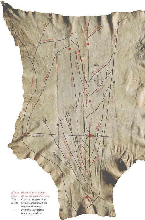
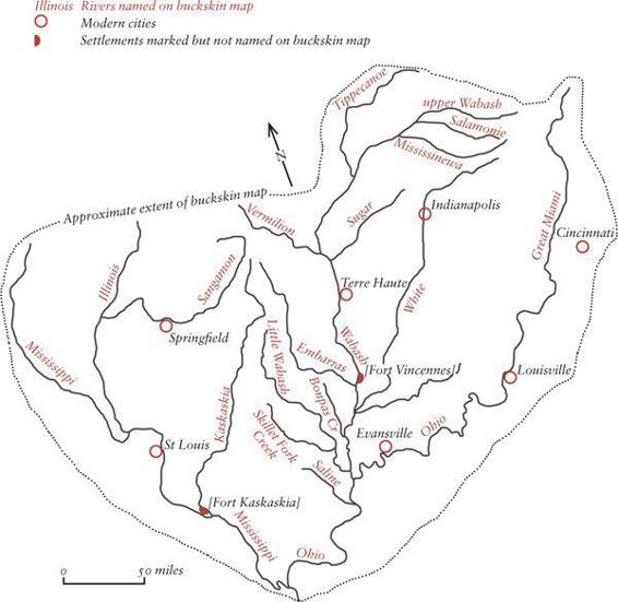
The map is roughly 100 by 126 centimetres (40 by 50 inches), and its shape is defined by the deerskin it is drawn on. The deer itself seems very present, for we can see exactly how it died: there are holes in the skin from a musket ball that passed from the animal’s right shoulder to its rear left flank, almost certainly going through the heart. This deer was killed by a top-class shot, someone who knew how to hunt. The map is only faintly visible on the skin now, but if we compare it with a modern map, we can see we are surveying the vast drainage basin formed by the confluence of the Ohio and the Mississippi, an area of more than 40,000 square miles in a V-shaped region between the rivers. We are just below Lake Michigan, in what will become the states of Illinois, Indiana and Missouri.
It is this area that after 1763 British settler companies wanted to exploit, and the map is the record of one of many conversations between these invasive settlers and the Native Americans. Near the centre of the map is the phrase ‘Piankishwa sold’.
The Piankishwa (or Pinkashaw) were a tribe of Native Americans living in an area that now includes modern Indiana and Ohio. The map was probably made for the Wabash Land Company, which had been set up to buy tracts of territory along the River Wabash from the Piankishwa in 1774–5. G. Malcolm Lewis, an expert on maps and North American Native cultures, elaborates:
It was almost certainly made in connection with an attempt by a Philadelphia firm of merchants to purchase land in the Wabash Valley on what is now the border between Indiana and Illinois. This involved the use of the map, which shows boundaries that were obviously being intended for purchase. In fact, the whole project came to an end because this was the very eve of the Revolutionary War. So it was almost certainly made and used in 1774–5, in connection with the attempted Wabash land purchase. It is undoubtedly Indian in style: it has all the characteristics of an Indian map. Rivers, for example, never show the sinuosities, they’re almost always straight … it was almost certainly used in the process of negotiating with the Piankishwa Indians to try and buy land.
The words ‘Piankishwa sold’ suggest that the map is a record of an already agreed land transaction, but in fact this deal was never ratified by the British colonial authorities. It was illegal, breaching official treaties. In any case, it is unclear what it could have meant to the Piankishwa Indians. The Wabash Company used interpreters, but plenty was lost in translation.
They have deposed that they served as interpreters … with the chiefs of the different tribes of the savage nation of Pinkashaws, relative to the purchase of lands as above mentioned, specified and written in the aforesaid act … the said witnesses, in their quality as interpreters, have done for the best in their souls and consciences and have faithfully and plainly explained to the said chiefs … to which they have set their ordinary marks, with their own hands.
Although this report says everything has been ‘faithfully and plainly explained’ to the chiefs, the Piankishwa could have had no concept of European-style land purchase. Settler approaches to land were completely alien to Native Americans, who thought of their land as both a literal and a spiritual birthplace – not territory that could be given away or sold.

The map above is a transcript and interpretation of the marks on the buckskin map. It primarily identifies and names rivers, but additionally shows the road built between the forts at Kaskaskia and Vincennes and two dotted boundary markers; it identifies some other native settlements without naming them, and shows the areas occupied by the Piankishwa, Wea and Kaskaskia peoples. The map below is a modern topographical map of the area depicted in the buckskin map.

What the map shows above all is rivers. In the centre, running down the spine of the deer, is the Wabash River – hence the Wabash Land Company – into which other rivers come in as straight, angled lines placed like vertebrae, except for the Mississippi, which runs down the left and curves around the bottom to the right. It shows the rivers, where the people are grouped together, not the land over which they roam and hunt. This is a map about communities, not geography, about habits of use, not patterns of ownership. So, rather like the map of the London Underground, it does not show accurately the physical distances on the ground. Instead, it indicates the the time it takes to travel between them. The Native Americans, like everybody else, mapped what mattered to them. Tellingly, although the map includes all the rivers, it shows almost exclusively the settlements of the Indians. Virtually none of the European settlements are there. St Louis, for example, which was already a great centre of trade and communications, just is not shown. European maps of the same area do effectively the same in reverse, showing the European settlements but not the Indian ones, plotting the space not in use. Two quite different readings of the same physical experience: you could hardly have a better demonstration of a central Enlightenment problem, the difficulty of any society in trying to understand another.
If the Indians didn’t understand the notion of exclusive land ownership, the Europeans could not grasp the Indians’ intense spiritual relationship to their land, the notion that the loss of earth was in some measure the loss of heaven. David Edmunds, Professor of American History at the University of Texas, elaborates:
I think the Native American relationship with the land is very important. You have to understand that land for tribal people is not a commodity. It was never a commodity, it was a place where you lived, that you shared, that you utilized, but it was not something that you particularly owned. One could not any more own the land than one could own the air above the land or the rain that fell on it or the animals that lived on it. Land is so important and place is so important to tribal people that history for them is more a function of place than of time. People are associated with a particular region, the region is the centre of their world … consequently, that land is so intricately bound into the very soul of most tribal people that it’s not something that you trade back and forth. And when they were forced to trade lands in the early part of the nineteenth century, and to give up land, in order to survive, it was a very traumatic experience for them. Another thing to remember is that most of the religious beliefs of tribal people are site-specific, and by that I mean that their cosmology, the powers in their universe, are also tied to the particular area in which they live.
The settlers failed to push through this particular land deal, which was struck down by the British colonial governors. A few years later, this tension between settlers wanting land and the British Crown eager to maintain good relations with the Native American chiefs would be one of the elements that triggered the War of Independence. But independence did not make the problem go away. US state governors faced the same dilemma as their British predecessors, and they, too, had to strike down more attempts at land sales between the Wabash Company and the Piankishwa that breached existing treaties. The map and the abortive negotiations around it remain as evidence of three quite different ways of thinking about the world – those of the Native Americans, whose land it has been from time immemorial, the settlers who wanted to appropriate it, and the authorities in London, mindful of Goldsmith’s strictures, who tried to mediate a solution, but were powerless to enforce it.

Australian Bark Shield
AROUND AD
1770
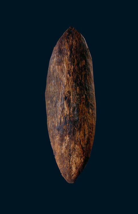
This is one of the most potent objects in the book, one which has become symbolically charged, freighted with layers of history, legend, global politics and race relations. It is an Aboriginal shield, one of the very first objects brought to England from Australia. It was brought here by James Cook, eight years before the fateful encounter described in
Chapter 87
. We know the precise date it came into Cook’s hands – 29 April 1770 – because we have written accounts of the day from Cook himself and from others who were with him. But the indigenous Australian who owned the shield did not write, which is why a history from objects can be so important: for the unnamed man confronting his first European on the shore at Botany Bay nearly 250 years ago, this shield is his statement.
Cook’s log records his arrival on the east coast of Australia, just south of the site of modern Sydney, on ‘Sunday 29th in the afternoon winds southerly and clear weather with which we stood into the bay and anchored under the south shore’. The ship anchored at what would come to be called Botany Bay, thanks to the collecting work of the botanist Joseph Banks, who travelled with Cook. The ship’s log continues:
Saw as we came in on both points of the bay several of the natives and a few huts … as we approached the shore they all made off except two men who seemed resolved to oppose our landing – as soon as I saw this I ordered the boats to lay upon their oars in order to speak to them, but this was to little purpose for neither us nor Tupia could understand one word they said … I thought they beckoned to us to come ashore, but in this we were mistaken for as soon as we put the boat in they again came to oppose us, upon which I fired a musket between the two, which had no other effect than to make them retire back where bundles of their darts lay and one of them took up a stone and threw it at us, which caused my firing a second musket load with small shot and although some of the shot struck the man, yet it had no other effect than to make him lay hold of a shield or target to defend himself.
At this point the diary of Joseph Banks picks up the story:
