Stonehenge a New Understanding (36 page)
Read Stonehenge a New Understanding Online
Authors: Mike Parker Pearson
Tags: #Social Science, #Archaeology

In planning an excavation on this site, the work of the Gaffney brothers was important. Quite a few archaeologists have a relative in the business: Second-generation archaeologists are fairly common (archaeological children seem to either love or utterly loathe their summers necessarily spent hanging around excavations) and pairs of siblings aren’t unknown. In the case of the Gaffneys, older brother Vince, of the University of Birmingham, has been interested for many years in the Stonehenge palisade, and younger brother Chris, of the University of Bradford, is a geophysicist. They had just developed the prototype of an improved magnetometer, mounted on a handcart with an on-board GPS. It can cover ground much faster than conventional machines, and provides sharper resolution of below-ground anomalies. Wheeling his cart across the field, looking like an ice-cream vendor late for an appointment, Chris was able to track the course of the palisade ditch as it continued southward up the hill, split into two and headed off to both the south and the west.
In 2008, we set out four trenches in this huge field, using the geophysics plot to decide where to put them. One trench covered the junction where the palisade ditch split in two. The second was positioned south of it, where a recent pipe trench had obscured the magnetometer’s plot of the ditch. Both areas were at the heart of Julian Richards’s worked-flint concentration, so we hoped that we might pick up traces of a Neolithic village. The third trench was placed by the palisade ditch far along its west fork, beyond a section in which the ditch appeared to have a couple of gaps. The magnetic anomalies here, we thought, might just be pits in a settlement. The fourth trench was further north, closer to the A344 and the visitors’ center; here we wanted to find out whether a line
of magnetic anomalies were more Mesolithic postholes, like those under the nearby parking lot.
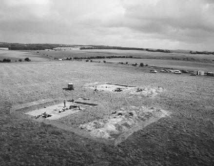
In the field west of Stonehenge, we dug a number of trenches to explore the enigmatic palisade ditch. Stonehenge is visible to the right beyond the cars.
The field is owned by the National Trust, which insisted that we remove the turf and plowsoil entirely by hand. We were aghast. For Josh and fellow site director Paul Garwood, Vince Gaffney’s colleague at Birmingham University, this was a Herculean undertaking. Their team had to lift the turf and sieve all the topsoil across an area half the size of a football pitch—and they had to do it fast. We spent a lot of our grant money building a battle fleet of new sieves, and raided the storage areas of five universities to round up enough shovels, spades, and buckets. Even with a small army of students and volunteers, it took two whole weeks to get to the point where we could begin to excavate the archaeological features beneath the topsoil. Working conditions on this exposed slope were often miserable, and we felt the students were never going to forgive us.
We counted up everything found in the sieves and recorded, grimly, that we could have estimated the total quantity of worked flints in the plowsoil by sieving just a sample of it. As our geophysics and augering had shown (and as aerial photographs, the tenant farmer, and Julian Richards’s old Stonehenge Environs team had confirmed many times), this field has been heavily plowed for centuries. Although the worked flints survive plowing, more fragile remains, like bones and pottery, don’t.
We felt our hand-digging had been a waste of time and effort (not to mention money); we could have dug an appropriate number of our customary meter-square test pits and then machined the topsoil and come up with the same result. Months later, though, as we studied the flints in the lab back in Sheffield, we realized that the laborious sieving of the field’s topsoil had been worthwhile: Many of the flints recovered were long blades from the Mesolithic. We had discovered the location of a Mesolithic campsite close to the site of Stonehenge and just 400 meters south of the pine posts under the parking lot. Long before the Neolithic, people had camped in this small valley; perhaps this was where they lived when they erected those gigantic posts.
In terms of Neolithic remains, however, the results were disappointing. The palisade ditch had been cleaned out and re-used in the Middle Bronze Age as a boundary that formed part of a Bronze Age farming landscape of fields. We couldn’t find anything to date the palisade ditch, but the fact that its line was continued by the Bronze Age ditch makes it pretty likely that it’s only a little bit earlier. There was no trace of any Neolithic activity, so the density of flints recovered on the surface was indicative mostly of later activity from the middle and end of the second millennium BC. Even when knowledge of metallurgy spread and bronze tools became available, people continued to work flint. Unfortunately, the vast mass of Bronze Age flint work looks no different from the worked flints of the previous millennium; it can be impossible to tell them apart unless you find diagnostic tools, such as arrowheads, whose distinctive shapes change through time.
After the field ditch had silted up, around 1250 BC, Late Bronze Age people buried three infants in the top of it, together with a whole pot and a beautiful carved small chalk pig. The Stonehenge pig is an endearing
little object that attracted a surprising amount of media interest. Someone thought it looked more like a hedgehog, so the British Hedgehog Society was contacted to share its views. On the other hand, most of the diggers agreed that the little figurine’s long flat ears left no doubt that the artist had intended to represent a pig.
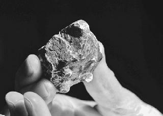
A carved chalk pig, dating from the Late Bronze Age, was found in the upper layers filling the palisade ditch. The pig has four “button” feet, a snout, and floppy ears.
Paul Garwood found that where he was digging, over in the westernmost trench in this field, was part of a Middle Bronze Age settlement. In the lee of a deep ditch was a group of postholes and small pits containing Bronze Age pottery. In the northern, fourth trench, our possible line of Mesolithic postholes turned out to be four tree holes of Roman and later date; the fact that there were four in a line was pure coincidence.
We were all disappointed not to find any Neolithic activity in this area west of Stonehenge, but we had learned an important lesson. This high chalkland, far from sources of fresh water, was not a place for Neolithic farming, even though it had been the site of an earlier hunter-gatherer settlement. Only when people had become fully sedentary farmers, from 1500 BC in the Middle Bronze Age, did they properly colonize this dry landscape, dividing it up into fields for their grazing sheep and plowing up the grassland for arable fields of wheat and barley. A good proportion
of the huge quantities of worked flints in the topsoil is likely to date from this period, much of it brought onto the fields in garbage carried from the settlements to be spread as manure.
We now understood that the palisade ditch was the first land boundary to have been laid out across Stonehenge’s open grasslands. Although it stopped in the area of the old visitor center, after a gap of about 400 meters it then continued northward alongside the Stonehenge Avenue before curving westward across the ruined banks of the Cursus. The northern stretch is called the Gate Ditch; California Dave led a team digging a short section where it runs alongside the avenue, and found that it too had held the posts of a timber palisade.
Julian Richards’s Stonehenge Environs Project showed that, after the Copper Age, the entire area around Stonehenge was encroached upon by these Bronze Age field systems, visible from aerial photographs.
6
Once known as “Celtic fields,” they have nothing to do with Celts. These lattice arrangements of field ditches mostly date to the Bronze Age, but continued in use into the Iron Age.
Interestingly, although the palisade ditch passed close to Stonehenge, the Bronze Age farmers gave Stonehenge itself a wide berth, leaving it untouched within an island of open ground that extended northward to beyond, where the avenue changes direction from its solstice axis and heads east toward the river. Stonehenge was evidently still treated as a place of respect at this time, and it was still visited even though construction had ended. In fact, all excavations at Stonehenge put together have recovered nearly as much pottery from the period 1500–700 BC as there is for the period 3000–1500 BC.
7
Most of it comes from the interior of the sarsen circle and from the ditch.
The late summer of 2008—the year in which we dug both the palisade and the Aubrey Hole—was wet and cold. In previous years, our campsite beside the Avon at the Woodbridge Inn in North Newnton had been a happy haven of sunshine and tranquillity, but that season it turned into a quagmire of mud and misery. With a team of 160 diggers living there, our feet soon churned up the grass. We tried scattering bales of straw to dry it out but the straw soon rotted into a fetid mess. The floor of the tent where we ate our supper turned to liquid filth.
Everything was covered in mud—tents, equipment, and clothing. The vans and minibuses, perpetually stuck, made things worse spinning their wheels in ever-deepening ruts. Having to push seven heavy vehicles out of the swamp every morning made a bad start to each day. The sewage truck emptying the portable johns had to be towed out by a tractor—he wouldn’t be coming back. Outbreaks of trench foot were reported. The students either coped—when the going gets tough, the tough have another party—or wimped out. It was crunch time: Do you want to be an archaeologist or would it be sensible to consider a rather more indoor career?
Although the campsite was horrible, conditions in the trenches were perfect. Plenty of rain on the free-draining chalk soils brought out the color contrasts and kept the ground soft. In an entire month we lost only half a day’s digging because of the rain. On the north side of Stonehenge, our main aim that year was to reopen and extend trenches dug by Richard Atkinson into the Stonehenge Avenue, to find out more about its dating and sequence. Atkinson had left barely any records of six of his trenches—just two plans, a single section drawing, and two photographs.
8
Half a century later we intended to finish the job of recording his excavations. Two of his trenches, dug in 1978, had been properly recorded, and even published, by John Evans, a colleague of Atkinson at Cardiff.
9
I’d known John Evans in his later years, when he was a professor of environmental archaeology. He became the leading specialist in land mollusks—”snail Evans” to distinguish him from lots of other archaeological Evanses—and was one of those people who’s interested in everything. He’d had some difficult years when alcohol almost got the better of him, yet his mind was razor sharp and you never knew what he was going to say next. Conversations with him were always challenging and he never held back, always saying exactly what he thought.
These days, mavericks like John don’t get jobs in universities—or if they do, they don’t last long. Gone are the days when a university lecturer can stare at an expectant class and tell them to just get out (in four-letter words), because he’s depressed and really doesn’t want to talk to them. Yet John’s students adored him—he was a witty, clever, and unruly man, hugely enthusiastic and inspirational. A Stonehenge gift-shop coffee mug was John’s only audiovisual aid for an excellent lecture
he sometimes gave on Stonehenge. Sadly, he succumbed to throat cancer in his early sixties.
When we reopened the trench that John had dug, we found in its side the precise spot where, exactly thirty years earlier, he’d taken a snail sample; it may seem strange that this snail sample could be famous, but for all the project directors this was a really historic spot, and memories came flooding back. I’d never thought to ask John directly about his work at Stonehenge, having no idea that I’d eventually be reopening his trench. Now it was too late: We’d have to learn what we could from what he and Richard Atkinson had left behind.
The Stonehenge Avenue runs dead straight northeastward for about 500 meters from Stonehenge until it turns sharply east, at its elbow. At this point, it dips downward steeply into the dry valley of Stonehenge Bottom, running along the top of a spur before dropping off its end. In Stonehenge Bottom it curves eastward, but its earthworks are very difficult to see here, disappearing as it climbs the east side of the valley. The top of the slope is called King Barrow ridge; as the avenue crests this ridge, it passes through a line of round barrows.