Stonehenge a New Understanding (16 page)
Read Stonehenge a New Understanding Online
Authors: Mike Parker Pearson
Tags: #Social Science, #Archaeology

We found another three houses down the slope from these two. In all of these we identified beam slots for beds set around the central fireplace but no elaborate fittings like those found in the large house. The houses’ doorways were difficult to spot but two faced west and the third to the south. This group of buildings provides a glimpse into a society that was not equal in terms of how people lived. The large house was near the top of the hierarchy (literally, too, by being at the top of the slope) and it had all the features of a family dwelling. With floor areas of almost 25–30 square meters, these houses were certainly big enough to each accommodate a nuclear family of parents and children. Perhaps the head family lived in the top house and their relatives or dependants lived in the smaller houses lower down the slope. The piles of broken cooking pots in the rubbish heaps outside these smaller houses form a stark contrast with the almost shard-free surface of the large house and its compound; perhaps the people in the small houses did the cooking for the residents of the large house. How many more households formed this segment of the community is difficult to tell, but the Skara Brae village seems to have consisted of nine or ten houses as a social unit.
While part of the team concentrated on excavating the delicate house floors, Julian opened two trenches inside the western half of the henge itself. Back in 1996 a team of geophysicists had discovered a group of five ditched enclosures in this part of Durrington Walls. These enclosures formed an arc, running north to south, with the largest—about 40 meters in diameter—in the center. This largest enclosure was circular and its entrance (facing east down the slope) was visible on the geophysics plot. This enclosure had actually first been located many years before, in the 1920s, from aerial photographs of cropmarks. Were these various features going to be Neolithic, or were they Iron Age like the ditch we had dug in 2004? Positioned on the slopes above the Southern
Circle, whatever they were, they would have had fine views of the valley leading down to the river. We selected the largest enclosure and its southern neighbor for investigation. At the center of each, the magnetometer showed a small hot spot—would this be a prehistoric burial?
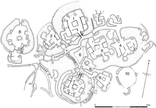
A plan of the Neolithic village of Skara Brae in Orkney. The Durrington Walls houses are very similar in plan and internal organization but were built in wood rather than stone. A photograph of House 7 is shown in Chapter 4.
The mechanical excavator removed the topsoil, revealing pits cut into the lower part of the colluvium within the large enclosure. As the students excavated these, we could see that they were grain-storage pits containing Iron Age pottery—not the period of prehistory we were looking for, but not a surprising find either, as much of the interior of Durrington Walls was re-used by Iron Age farmers two thousand years after it was built.
Another 30 centimeters deeper, we reached bare chalk. Here the hot spots turned out to be fireplaces in the centers of square houses just like those we had found down the valley beside the avenue. There was a house within each enclosure but their preservation was not good. Here in the interior of the henge, the top of the Neolithic ground surface had
been scoured away before the Iron Age and the plaster of the house floors had been eroded—except directly under the hearth, where the heat from the fire had made it as hard as rock. Each house was surrounded by a circular row of holes for fence posts. The house to the south had then also been encircled by a ditch, its entrance to the west, with the chalk deposited outside the ditch. This ditch and bank had turned the house into a mini-henge after its original fence had gone out of use.
The sequence in the large enclosure was slightly different. This house and its surrounding fence were positioned at the center of a large circular enclosure whose bank had first been positioned inside the ditch, just like at Stonehenge, but had later been moved to outside the ditch when the ditch was dug out again. Although it had initially had a defensive-looking boundary feature (ditch then bank), this enclosure too had been turned into an inward-looking henge (bank then ditch). There were other unusual features within this large enclosure.
First, the entire ground surface within the enclosure had been leveled. We had seen this kind of landscaping elsewhere, associated with the construction of each of the houses on the slope above the avenue and for the Southern Circle itself. Outside the circular fence a pit had been filled with the butchered remains of a whole pig, the remnants of a small feast. Halfway between an opening in the fenceline and the entrance to the enclosure, two huge postholes lay close together. They had held posts almost a meter in diameter. What was odd was that the postholes’ bases were at different depths. Julian wondered if this had been a way of making sure that the tops of the posts were at the same height. Perhaps these posts had supported a wooden lintel on their tops to make a trilithon-shape in wood. To their south, and right against the edge of the excavation trench, Julian found another similarly massive posthole. Was this part of another “tridendron,” one of two sets of massive posts flanking the approach to the central house?
Whoever lived here was clearly very important indeed. Although the house’s floor area was no bigger than that of the large house further down the valley, it had footings for 1.8-meter-wide posts arranged in a square around its central hearth. These must have given this particular house a far more monumental appearance than the others; perhaps
these hefty posts supported a high roof. All the floor deposits had been washed away long ago, so there were few clues to what had happened inside the house. The fills of all the holes for the wall stakes and fence posts were clean as a whistle, completely unlike the black, organic fills in the corresponding features around the houses lower down the valley. Even the fill of the pit with the dismembered pig was much cleaner than equivalent pits associated with those houses. This was a very clean place despite the central hearth having been in long-term use. Whoever kept the fire burning also made sure that very little domestic rubbish was left lying about.
Julian favors this building having been used as a spirit house, a place where the supernatural could be visited by the living. A guardian would have periodically tended the fire but otherwise no one actually lived here. My preference is that it was used as a dwelling by a leading family, who might have received guests here or arbitrated on matters of justice. Perhaps the family’s food was brought to them from a cooking area elsewhere, at the back of the enclosure or further away.
Having found houses both inside and outside the henge, we began to wonder if Durrington Walls had been a much larger settlement than we’d first appreciated. What if the entire henge enclosure, all 17 hectares (42 acres) of it, turned out to be a village? Recorded on Kate’s geophysics plots, there are hundreds of magnetic hot spots similar to the two that turned out to be hearths—many of these could be the sites of former houses. Sadly, we will never be able to identify whether or not they are all houses without excavation over an enormous area, an impossible task logistically and something that English Heritage and the National Trust (who own most of the Durrington Walls henge) would never permit.
By 2006 it was clear that the houses down by the avenue had been occupied before the ditch and bank of Durrington Walls were constructed. The settlement had been in use before the henge was built, and the earthworks were not a circuit of “town walls.”
o
Since we were certain that the settlement predated the henge bank and ditch, we knew we should find well-preserved occupation evidence on the
buried ground surface beneath the henge bank. Turning to the records of previous digs at Durrington Walls, I found what I was looking for. In 1917 a local archaeologist, Percy Farrer, dug a narrow trench through the bank on the west side and found a thick, black layer of occupation debris.
8
In the early 1950s, archaeologists monitoring a trench for utilities along the old A345 road running through the henge observed similar deposits where the pipe trench cut the bank at the north and south sides.
9
We ourselves dug five small trenches into and beneath the rampart on the east side of the henge and discovered thick occupation layers.
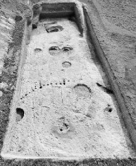
An elevated view of Julian Thomas’s trench showing the central square house and the postholes of its circular palisade fence within the largest of the Western Enclosures.
Inexplicably, there was a lack of such evidence from Geoff Wainwright’s wide trenches in 1967, even though these had run through the north and south banks. He had, however, found buried soil under the south bank, both on the roadline and in a narrow pipe trench close to where our own excavations would be.
10
While the mechanical excavators were removing this buried soil, his supervisor Pedro found lots of
artifacts in it—more than three thousand worked flints and a hundred-plus potshards—but there had been no sign of any house floors. The north bank had also preserved a buried soil underneath it, but there was very little Grooved Ware pottery. Instead, Geoff and Pedro found a small area of occupation here with an earlier style of pottery radiocarbon dated by charcoal to around 3300 BC, the best part of a thousand years earlier than the village.
The absence of any evidence for Grooved Ware houses in the buried soil under the north bank was not difficult to explain. A geophysical survey carried out in 2004 made clear that there had originally been an entrance through the north bank, and Geoff’s excavation was fortuitously located on what was actually a later blocking ditch that had been dug to close off this entrance.
11
This explained why the northern ditch as recorded by Geoff was unusually shallow and why it produced surprisingly late radiocarbon dates of 2200–1700 BC.
12
The geophysics plot also revealed a similar blocked entrance on the south side, leading to Woodhenge. We can presume that these entrances to the henge were access routes into the settlement, which explains why Geoff’s team found no Grooved Ware occupation or houses beneath the north bank.
Geoff is certain that his old colleague Pedro would not have missed any house floors while machining off the buried soil beneath the south bank. He was an extremely experienced archaeologist who had worked on digs all over the world. On this I have to disagree with Geoff; I think that the section drawings and photographs from 1967 show at least two and probably more houses, visible as level, horizontal stripes in the sides of the excavation.
13
One even has a hearth and a small posthole. My guess is that there may have been up to a dozen houses under this part of the south bank, based on the 1967 records and on the density of houses where we dug. I’m not criticizing Geoff and Pedro for this probable mistake—no one is infallible, and in 1967 not only were they teaching themselves and others how to use mechanical diggers for topsoil stripping, but no one had ever seen a Neolithic house floor; when we began work nearly forty years later, we were standing on the shoulders of giants.
Further confirmation came in 2007, when we dug through the south terminal of the bank at the east entrance to the henge. This bank was
made from the upcast from the Neolithic digging of the ditch. Layers of material thrown up from the ditch had been tipped one on top of another, so that the topsoil was covered by chalk rubble. That Neolithic topsoil contained large blocks of cob-type walling, just like that of our large house; we think that there was at least one house in this area, which was demolished and removed by the Neolithic builders in order to dig the henge ditch.
There are two important factors to take into account when comparing our success at finding houses to the apparent absence of houses in the 1967 excavations. Back in the sixties, archaeologists had little knowledge of what Neolithic house floors might look like. By sheer chance, Colin and I had developed a very specific knowledge of these very ephemeral surfaces because of their occurrence on the sites in Scotland where we had been working over the previous two decades. Even so, when we started digging at Durrington Walls in 2004, we could easily have machined off the first house floor that we found because it was so slight and so shallow. Fortunately, we had dug some test pits beforehand and knew not to go to the top of the subsoil with the digger bucket. We were also conducting a research excavation with no pressing deadline; if we failed to finish, we simply covered the trench over and came back the next summer. Geoff’s team, however, had just three months in which to complete the job. By comparison, it took us four months with a similar-sized (but much more inexperienced) team to dig an area less than a fifth of the size of the 1967 trench—and that’s without having to empty any deep henge ditches.