Stonehenge a New Understanding (46 page)
Read Stonehenge a New Understanding Online
Authors: Mike Parker Pearson
Tags: #Social Science, #Archaeology

Stukeley’s drawing of the Devil’s Den at Clatford in 1723. The stone structure of this type of tomb, probably a portal dolmen, was never covered by a mound.
Kate’s team also carried out a geophysical survey in the next valley to the west, around the Devil’s Den, one of the lesser-known megalithic monuments of Britain.
8
It consists of a pair of squat uprights supporting a partly slumped lintel, or capstone; other, smaller sarsens lie within the monument, and at least three more have been hauled away and dumped in the nearby hedge. Reading the antiquarian literature (or a Google search) will reveal some bizarre folktales associated with this odd structure. For example, at midnight the devil may appear driving a coach and horses. My favorite is the apparition of a giant rabbit with eyes that blaze like fiery coals—what an unthreatening natural world Britain is, if the worst creature that the Medieval mind could conjure up was a big, scary bunny.
The Devil’s Den has been thought to be the chamber of a Neolithic long barrow, though Atkinson and Piggott carried out a small excavation here in 1960 and found nothing. Stukeley drew a particularly fine illustration of it, showing the unworked stones of the trilithon-shaped stone structure, and three other unworked slabs lying next to it. What grabs my attention in his drawing is that the monument sits on top of a mound and not within one. This was surely never a chambered tomb beneath a mound. It is more likely to be the remains of an Early Neolithic portal dolmen sat upon a mound. Our geophysical survey revealed remains of a second mound immediately north of it.
Given the likelihood that Stukeley’s stones at Clatford had been assembled from nearby quarry sites prior to being taken across the river, Hill’s route—at least its initial stretch—seems more plausible than Atkinson’s. I would certainly agree with it as far as Knap Hill and the descent into the Vale of Pewsey. Thereafter, I’m not convinced that the Avon valley was the easiest route for dragging the stones. There’s also no particular reason to think that the avenue has to mark the direction from which the sarsen-dragging teams approached Stonehenge; the avenue’s banks and ditches were created
after
the arrival of the sarsens, so it wasn’t a marked-out route at that time.
Colin’s and Kate’s work on the north side of Stonehenge has shown that the sarsen-dressing area was not centered on Stonehenge’s main entrance but was slightly further west, suggesting that the stones were not dragged here from the northeast (along the line of the avenue) but from
the north, as Atkinson thought. Coming from that direction, the teams of stone movers would have skirted to the east of Robin Hood’s Ball causewayed enclosure and the Lesser Cursus and passed by the west end of the Greater Cursus.
How did they get from the Vale of Pewsey below Knap Hill to Salisbury Plain next to Robin Hood’s Ball? The northern escarpment of Salisbury Plain is extremely steep. I needed to explore the area below that northern edge and find the more gentle inclines, to see if anywhere looked even slightly promising as a suitable route to the top. Driving from west to east, I’d covered most of the ground and nothing looked good. Then, there it was—a long, narrow spur leading gently uphill from the bottom of the valley. Where was I? The nearest road sign pointed to the small village of Marden, a bridging point across a small stream in the bottom of the Vale that flows eastward into the Avon. The name made me laugh out loud—it was all so obvious.
Marden was a really important place during the Neolithic. In fact, it is one of the five great henge enclosures of Wessex, almost as large as Durrington Walls but rarely mentioned in popular books about Wessex and seldom visited except by archaeologists. There’s very little to see on the ground and it lacks the number and density of surrounding Neolithic and Early Bronze Age monuments found in the vicinity of all the other Wessex henges, from Dorchester in the south to Avebury in the north. Unlike the other henge enclosures, Marden’s henge bank and ditch do not extend around the entire circuit, leaving the southern side of the henge open to the stream that flows close to it.
In 2010, a team from English Heritage, led by Jim Leary, carried out excavations inside the Marden henge.
9
One of its entrances was excavated back in 1971, by Geoff Wainwright’s Central Unit.
10
They found the postholes of a timber circle and plenty of Grooved Ware. Radiocarbon dates from finds at the bottom of the ditch put its construction in the period 2570–2290 BC, so this henge is likely to have been contemporary with Durrington Walls and Stonehenge’s sarsen phase.
Antiquarians recorded the presence of an enormous mound within the Marden henge enclosure. It’s now completely flattened but its position was pinpointed by the English Heritage team, and one of the research aims of the 2010 excavations was to find the undisturbed basal
layers of this vanished mound. Jim Leary’s team also investigated a smaller henge within the main henge. Under its bank they found the chalk-plaster floor of a rectangular house, similar to those from Durrington Walls, except that its central area was slightly sunk below ground level. Within the henge’s southeast entrance, Jim discovered the remains of a gravel roadway leading toward the River Avon.
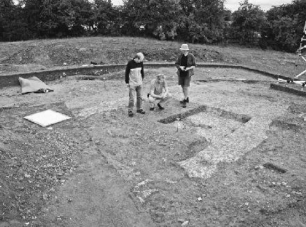
Landscape archaeologist Dave Field (left) discusses the excavations at Marden in 2010 with site director Jim Leary (center) and colleague. They are standing on a layer of soil on top of the chalk floor of a Neolithic house. The edge of the circular hearth is visible in front of them.
If the Stonehenge sarsens came this way, their route up the incline on to Salisbury Plain would have involved crossing the stream at Marden. Was this why the henge was here, to mark or signal the crossing point where the stones had to be taken across the stream and its surrounding boggy ground? To cross here, the stone pullers would have needed to build a substantial causeway. It’s just possible that remains of piled timbers to support a causeway might survive here and at Clatford, deep in
the bed of the stream and its wider floodplain. A future archaeologist finding them would be able to date the tree rings to the very year in which the trees were felled to build the causeway. One day, we may be lucky enough to date Stonehenge’s sarsen construction to within less than a decade.
18
__________
The wet summer of 2008 had at times made our excavations a miserable experience that none of us wanted to repeat. Getting the campsite evacuated at the end of the dig that year took on the dimensions of a military operation. Nonetheless, we still had enough energy for an end-of-dig party—even though the tent was unusable and guests had to put up with standing in ankle-deep mud. It took the best part of a week to pack up and move out and, once back in Sheffield, another month to clean the equipment.
During this time, Tim and Geoff were gearing up for a big press announcement on the dating of the bluestones in the Q and R holes at Stonehenge: They now had the results of fourteen radiocarbon dates. It was announced on the BBC’s six o’clock news that Stonehenge had finally been dated with certainty—the sarsens were put up around 2300 BC.
I was not the only archaeologist to raise an eyebrow at this surprising announcement: All the existing evidence indicated that the sarsens were put up around 2620–2480 BC. Where did this new date—placing the sarsens several hundred years later—come from? The same evening a BBC
Timewatch
documentary on Stonehenge explained that a carbonized cereal grain from the 2008 excavation of a Q Hole had provided a date of 2300 BC. From what he’d found in his excavations in the 1950s, Richard Atkinson believed that the bluestone Q Holes date to before the erection of the sarsen circle. If a Q Hole has a date of around 2300 BC, therefore, then Stonehenge’s sarsen phase cannot be any earlier than
this date: The sarsens had to be later than the Q Holes, so must have been put up around or after 2300 BC.
The program went on to examine the argument for the healing properties of the bluestones. Tim and Geoff had found more chips of bluestones than chips of sarsens in their trench. This indicated—so they argued—that the bluestones were sought out by prehistoric people who chipped bits off them. The documentary didn’t try and explain the logical problem of why all these bluestone chips had been left lying around. If the chips were valuable, why hadn’t people taken them all away? If bluestones had magical powers of healing, why didn’t prehistoric people use these stones to build lots of other stone circles all over Britain?
Maybe the Stonehenge Archer—the man with arrow wounds who was the last person to be buried at Stonehenge—was shot because he’d tried to steal some of the valuable bluestone chips; three of these were found by John Evans in the soil filling the man’s grave,
1
and Tim wondered if these were deliberately placed grave goods. The argument against this is that the upper layers of the Stonehenge ditch in which the Archer is buried contain plenty of bluestone chips, any number of which could have ended up in the filling of the grave by accident. John also observed that the three pieces in the grave were not in any special position, which indicates that they were not deliberately placed in the grave.
I struggled to see how the new date for the Q Hole (and therefore the building of the sarsen circle) could make sense. This proposed date of 2300 BC was about two hundred years later than the existing radiocarbon dates that come from two antler picks, one from the sarsen circle and one from the south trilithon. The implications were considerable. Not only did the new date suggest these two antlers, from secure contexts, had somehow produced incorrect dates, but it also meant that the bluestones and sarsens had all been erected after Stonehenge had been in use as a cemetery, and also long after the village at Durrington Walls had been abandoned. Could the existing radiocarbon dates be wrong? If this new date was right, it meant that Stonehenge and Durrington Walls were not contemporary with each other after all, and that the timber circles were built long before the sarsens were erected at Stonehenge.
Did Tim and Geoff’s excavation results really lead to such a dramatic new conclusion? We suspected that the new date was wrong and that the stories in the press were garbled.
Geoff and Tim soon delivered a lecture for specialists at the Society of Antiquaries in London, and the hall was packed to the rafters. Dates are more important to archaeologists than treasure because they provide the framework for investigating the past. Without them we cannot investigate long-term evolution and change. So it was standing room only to hear what Tim and Geoff had to say. To the audience’s surprise (and relief), they explained that their dating was extremely tentative.
2
The date for the cereal grain from the Q Hole wasn’t 2300 BC: It was actually AD 780–990. The other dates from pieces of charcoal found in this feature ranged from 3370–3090 BC to AD 1480–1640. A pig bone from its bottom layer had dated to AD 1430–1620. Of six radiocarbon dates from this bluestonehole, only two were prehistoric—of these, one dated to before anything was built at Stonehenge (before 3000 BC) and the other was the date that the press had lapped up, 2460–2200 BC.
Of the other dates from the excavation, four were from AD 1600 onward. The remainder were from the Early Mesolithic (7330–7070 BC), the Neolithic (3090–2900 BC and 2880–2620 BC) and the end of the Neolithic (a human tooth from the turf line, dating to 2470–2230 BC).
This is all quite a lot to digest. Put simply, Tim and Geoff were wrestling with a sequence of dates that was completely scrambled. By the rules of stratigraphy, you have to date a layer by the latest thing in it. If we accepted the new dates, that would mean that the sarsen circle dated to AD 1670–1960 (that’s somewhere between King Charles II and the Beatles) and the Q and R Holes to AD 1480–1640. Even the most bizarre theories about Stonehenge don’t advocate that sort of date.
u
The problem that Geoff and Tim had encountered was bioturbation: Not only have people been digging around in Stonehenge since the Roman period, but animals have as well.
Charles Darwin knew about the processes of bioturbation, which was why he went to Stonehenge to find out more.
3
Earthworms can move
very big things, such as huge sarsen blocks, down through the topsoil by several centimeters. They can also move very small things, such as pieces of charcoal, cereal grains, and small pieces of pottery and bone, to much deeper depths. The reason is very obvious, and very annoying for archaeologists. Worms burrow through the soil, leaving worm holes behind them. Small things fall down into the worm holes—they change position in the soil. It’s also possible for worms to move small objects sideways and even upward, against gravity.
In 1995 two animal bone experts published the results of a simple experiment that they’d carried out using a glass fish tank.
4
They had filled it with soil and earthworms, and then placed the corpses of two voles and a mouse on its surface. Within twenty-four weeks, the earthworms had scattered the little bones throughout the soil, with most bones at a depth of 10 centimeters below the surface and some already at depths of more than 20 centimeters.