Remembering Conshohocken and West Conshohocken (2 page)
Read Remembering Conshohocken and West Conshohocken Online
Authors: Jack Coll

The borough of Conshohocken seen along the banks of the Schuylkill River, where the Lenape Indians once thrived, before being displaced by the Industrial Revolution.
Photo by Brian Coll
.
HE
S
CHUYLKILL
R
IVER
Conshohocken is a town built on a hill overlooking the Schuylkill River, pronounced Sku-kel, or Skoo-kull. The river is approximately 130 miles long and lies entirely within the state of Pennsylvania. The first known name of the river was Ganshohawanee, meaning “rushing and roaring waters,” presumably for the falls at the fault line near what is now the Fairmount Water Works. The name was given by the Delaware Indians, who were thought to be the original settlers of the area along the banks of the river.
There seems to be somewhat of a dispute as to who named the river the Schuylkill; after all, the Leni-Lenape Indians are considered some of the original inhabitants of the area. The Leni-Lenape migrated to the valley from the Mississippi Valley, taking advantage of the climate, river and rich planting grounds. It was the Indians who named the river the Schuylkill, meaning Hidden River. But a European discoverer named Arendt Corssen was one of the first Westerners to explore the area and sailed right past the mouth of the river. Corssen, who explored for the Dutch East Indies Company, was said to have named the river “Schuyl-Kil” because of the reeds, sedges and high grasses that hid the mouth of the river.

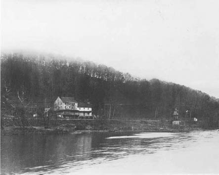
This photograph of the Spring Mill Ferry and Inn is perhaps the oldest photograph of the Conshohocken area. The ferry was established in the late 1700s, and the inn was owned and operated by Reese Harry from 1804 until his death in 1824. The inn was located on the west side of the Schuylkill in the Spring Mill section of the borough.
HE
L
ENI
-L
ENAPE
I
NDIANS
In the early 1500s, a group of Indians calling themselves the Leni-Lenape settled in an unspoiled wilderness in what is known today as northern Delaware, New Jersey, parts of New York and eastern Pennsylvania, including what is Conshohocken.
The Leni-Lenape Indian tribe settled on Edge Hill (Conshohocken) and called their home
Gueno Sheiki-Hacki-Ing
or
GuneuschigihackingâGuneu
meaning “long,”
schigi
meaning “fine,”
hacki
meaning “land,” with the locative ing, having the significance “at the long fine land.” The name Leni-Lenape is redundant, as if to say “the common ordinary people.” Lenape by itself is sufficient. The Lenape were composed of three different groups with a couple minor differences.

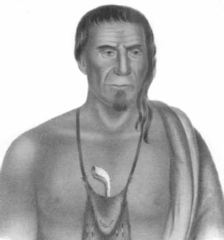
This portrait of Tish-Co-Han, an early Lenape chief, was painted by Hesselius, a Swedish artist. Tish-Co-Han means “he who never blackens himself.” In 1737, Tish-Co-Han signed the treaty known as the Walking Purchase. He was considered by members of the William Penn family as an honest, upright Indian.
Courtesy of Lower Merion Historical Society
.
The Lenape Indians were family oriented and did not seek hostile confrontations. They would always locate their villages near streams or rivers, where fishing for food and easy transportation made for easier living. The Lenape always fertilized the land with the planting of corn, beans, pumpkins, squash and tobacco. They lived in permanent villages and would only leave in their quest for food, furs and trade. The Indians did not live in teepees but rather in wigwams or longhouses that were much more permanent structures.
William Penn, who was credited with the planning and development of the city of Philadelphia, developed very good relations with the Lenape Indians. By 1683, after more than 150 years of the Lenape living along the river, Penn signed a treaty that would eventually lead to the demise of the tribe in Pennsylvania. Over the next two centuries, the Lenape Indians were moved to smaller territories, and by the 1860s, most of the Lenape remaining in the eastern United States had been sent to the Oklahoma Territory. Today, what's left of the Lenape nation lives in several parts of the United States, including Oklahoma, Wisconsin and Kansas.
ILLIAM
P
ENN AND THE
T
RINKET
P
URCHASE
William Penn, founder of the state of Pennsylvania, was a devout Quaker and very well respected by the Lenape Indians. He gained the trust of the Indians after signing several treaties, including the treaty that secured the village of Conshohocken.
Penn purchased Conshohocken, or at the time
Gueno Sheiki-Hacki-Ing
, as part of a much larger land deal with the Indians. In William Penn's deed of 1683, the lands between the Schuylkill and Chester Rivers, the line of the purchase, commenced “on the West side of Manaiunk [Schuylkill River] called Conshohocken.” (The river is now spelled Manayunk, meaning “where we go to drink.”) The deed was penned by Secane and Icquoquehan. It also stated as part of the agreement that the lands east of the Schuylkill to Pemmapecka Creek run “So Farr as ye hill called Conshockin on the said river Manaiunk.” The deed was signed by Neneshickan, Malebore and Neshanocke.
A couple of years later, in 1685, Penn again agreed with the Indians for more land “Beginning at the hill called Conshohockin on the River Manaiunck of Skoolkill.” This deed was signed by Shakahoppoh, Secane, Malibor and Tangoras.
Ownership pertaining to much of the deeded land would later be questioned due to the price Penn paid. Legend has it that Penn traded flashy trinkets for the land. The Indians believed that Penn was merely renting and sharing the land. The Lenape couldn't understand how any one person could own land. They lived in a world where the air they breathed was free, the wilderness around them, the river, the animals and the land were for everyone to share, not own. All the while, Penn had Indians sign legal deeds to the land, but the Indians never owned the land in the first place and legally were in no position to sell it.
ASHINGTON
T
AKES THE
S
TAGE, BUT N
OT
IN
C
ONSHOHOCKEN
The American Revolutionary War began as a war between the kingdom of Great Britain and thirteen united former British colonies in North America and concluded as a global war between several European great powers. The war that began in 1775 and was fought in several locations, including the eastern seaboard and northwest territories, came to Conshohocken on December 11, 1777.
General George Washington and the Continental army successfully held off British attacks in the Battle of Whitemarsh (December 5â8, 1777). On the morning of December 11, Washington's troops marched through Conshohocken, crossed the river at Matson's Ford and set up camp in Gulph Mills. General John Sullivan ordered wagons tied together to form a bridge at Matson's Ford so his troops could cross the river. Once on the West Conshohocken side of the river, Sullivan met with resistance from two thousand British troops led by Lord Cornwallis. Sullivan ordered his troops to retreat back across the makeshift bridge, destroying the bridge as they retreated. Sullivan led his troops to Swedesford crossing in Norristown and arrived in Gulph Mills on December 13 in a heavy snowstorm. Six days later, the order was given to march seven miles on West Gulph Road to Valley Forge to meet with Washington and endure one of the coldest winters in history.

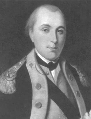
General Gilbert du Motier, Marquis de Lafayette, was at the center of a skirmish that took place during the Revolutionary War at the foot of the Matson's Ford Bridge in Conshohocken. On May 20, 1778, Lafayette used the little-known Barren Hill path to escape General William Howe of the British command. Lafayette's men encountered a fight that turned bloody when eight Americans and four Indian scouts were killed.
On May 20, 1778, the Revolutionary War once again was a focal point in Conshohocken, where the results were deadly. The skirmish centered on a twenty-year-old general named Gilbert du Motier, Marquis de Lafayette. General Lafayette was General George Washington's favorite and most loyal foreign officer. The young Frenchman departed from Valley Forge on May 18, 1778, with more than 2,200 Continental soldiers, heading toward Philadelphia. Lafayette's troops camped at Barren Hill, ten miles outside Valley Forge.
On May 20, General Lafayette was surprised to learn that his troops were surrounded by five of the most experienced generals, ready to attack. Lafayette met with his men outside St. Peter's Lutheran Church and decided that two generals, Enoch Poor and James Varnem, would lead the troops down a hidden path and into Conshohocken.
That hidden path was later named Barren Hill Road. The road led Lafayette and his troops to the Matson's Ford crossing. The troops crossed into the hills of what later would be West Conshohocken, but not without a skirmish. An attack at the foot of the Matson's Ford crossing on the Conshohocken side of the river, currently Fayette Street, left eight Americans and four Indian scouts dead from British gunfire. All twelve of the dead were buried at St. Peter's cemetery in Barren Hill.
General George Washington was very impressed with Lafayette's great escape. Conshohocken's Fayette Street was named after the general, as was Lafayette Hill in nearby Whitemarsh Township. Conshohocken also named a street after General George Washington, but despite all the speculation over the past two hundred years, George Washington never stepped foot inside Conshohocken's boundaries.
T
A
LL
S
TARTED WITH A
C
ANAL
In the early 1800s, the Schuylkill River was used primarily as a means of transportation for moving goods, particularly coal. However, as the demand for coal grew from the increased mills along the lower end of the river, the shallow Schuylkill River became tougher to navigate with heavier loads of coal.

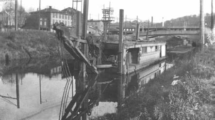
The canal system along the Schuylkill River was constructed over a twelve-year period, from 1816 to 1828, and covered 108 miles, including Conshohocken. This Conshohocken Canal photograph shows a barge dredging the canal in the 1920s, allowing heavier shipments of goods to travel to Philadelphia.
