A Durable Peace (44 page)
Authors: Benjamin Netanyahu

In addition, the topography of the Judean and Samarian mountains is particularly well suited for the delaying actions necessary
for Israel’s defense. To an invader from the east, this range is an extraordinary obstacle that must be overcome to reach
the Israeli coastline. Such an invader enters the West Bank in the Jordan River Valley, which is the lowest point on earth,
more than a thousand feet below sea level. He then has to fight his way up a cliff face that rises a daunting three to four
thousand feet within a space of seven to nine miles. This is terrain that, with the exception of a few tortuous routes, is
virtually impassable to tanks and other heavy equipment. No amount of electronic gadgetry can replace a stone wall thousands
of feet high as an obstacle to war. The West Bank thus provides Israel not only with strategic depth but with strategic height.
In withdrawing from the Sinai, Israel took upon itself considerable risks, but not ones that immediately jeopardized its existence.
For if the Egyptians were to violate the peace treaty by moving substantial forces into the Sinai, it would take these forces
several days to cover the 120 miles from the Suez Canal to the border of Israel. This would give Israel sufficient time to
mobilize its ground forces and intercept the Egyptian expedition in the desert before it reached the Israeli border. By contrast,
the distance from the West Bank to the Mediterranean is only ten miles. Were Israel to vacate the West Bank, hostile forces
could cover these distances in a matter of hours.
It is often difficult for non-Israelis to grasp just how tiny Israel is and what kind of military odds it faces. I suppose
this difficulty arises from the string of Israeli victories, extracted from the teeth of extinction. These tend to obscure
the fact that one defeat for Israel
means the last defeat. Further, because of their lack of familiarity with Israel’s geographical and topographical realities,
people in the West have a great difficulty understanding that Israel’s position vis-à-vis the Arabs could change from one
of relative strength to one of extreme vulnerability by shifting the border “just a few miles.”
How is it possible that the physical circumstances of the country that the press and television crews of the entire world
cover perhaps more than any other are so little understood by millions? After all, the map of Israel appears routinely on
the television nightly news. But there’s the rub: The map, with no reference to scale, is usually designed to emphasize Israel
and its “occupation” of the West Bank, which the viewer naturally believes to be, not thirty miles wide, but a substantial
piece of real estate—like, say, the west bank of the Mississippi, which stretches a thousand miles to the Rockies.
American visitors to Israel are often astonished at its tininess. In this they echo Mark Twain, who observed that “the State
of Missouri could be split into three Palestines, and there would then be enough material left for part of another—possibly
a whole one.”
6
It was only during the Gulf War, when the focus on Iraq required a larger map of the region that showed Israel to be the minuscule
thumbprint that it is, that many Western viewers gasped in amazement. But not even that conveyed Israel’s microscopic size
compared with the Arab world. The territory of the Arab countries is far larger than the land mass of the United States. Israel
in the pre-1967 boundaries is smaller than the state of Maryland, and the West Bank is a quarter that size.
7
To put it another way, if the Arab world were imagined as a football field, Israel could easily fit between the goalposts
on one end of the field. Its population is six million, less than the population of greater Los Angeles, as compared with
over 150 million Arabs. Further, the Arabs’ fantastic petrodollar wealth has allowed them to invest unlimited funds in buying
the latest weapons and building formidable arsenals. Consequently, Israel’s army is one-sixth the size of
the combined armies directly facing it and one-seventh the size of those of the entire Arab world.
8
If ever in the history of nations there was a clear-cut case of David facing Goliath, this is it.
Israel has had to face enemies on its eastern front who in short order could field thousands of tanks, planes, artillery pieces,
and rockets, and millions of men, reminiscent of the eastern front faced by NATO. But whereas the distance between the Warsaw
Pact lines and the English Channel was a thousand miles, Israel’s current width from its eastern front to the sea is forty
miles. This is bad enough, but Israel is now being seriously asked to reduce that distance to ten miles. Against such odds,
it could not survive.
I have a special kind of familiarity with these distances. It is an Israeli dictum that you get to know the country through
your feet, a cliché immortalized by endless blisters that Israelis acquire during military service. When I was in the army,
we used to hike the distance “from sea to sea” in a day’s march. We’d fill up a canteen with sea water from the Mediterranean
at five in the morning and empty it into the Sea of Galilee at five in the evening—twelve hours to cross the country on foot
from west to east. This one-day trek crosses Israel in its
present
width. Its previous width lent itself to a brisk run, which is what we used to do when I entered the army a few weeks after
the Six Day War. The paratroop base where I did basic training was situated right opposite Tuklarem, on the just-erased Jordanian
border. We used to run from the base to the sea in a little over an hour.
How can someone living in America or Britain or France comprehend the vulnerability of a country of such minuscule dimensions?
A plane trip from Montreal to Miami along the narrower north-south dimension of the United States takes three hours. I recently
flew into Israel with the same kind of jetliner, which was flying east and circled back for the landing at Lod Airport, near
Tel Aviv. From the time it crossed the Mediterranean shoreline to the moment it passed over the old border, two minutes had
elapsed. By the time it reached the turn (coming up over Jerusalem), another minute had elapsed. If it had continued eastward
it would
have crossed into Jordanian air space two minutes later. In other words, compared to the three hours it takes to fly across
America’s narrower dimension, it takes five minutes to do so in Israel. A jet fighter can cover the distance in three.
How to defend such a speck of territory against forces that approach the size of NATO’s is a tactician’s nightmare. It is
a question that was once asked of me in the heart of Africa. The head of an African state with which Israel had no relations
had invited me on a private and unofficial visit. After graciously receiving me, the African leader explained that he was
no enemy of Israel, but as he was a friend of the Palestinians, he wanted to know why we could not just give them the West
Bank and be done with it. I took one of the paper napkins that were served with the coffee and proceeded to draw the country’s
dimensions, the West Bank, and the forces arrayed against Israel in the east. “Mr. President,” I said, “you’re a military
man. Here, why don’t you draw the minimal borders necessary for our defense?” He said he saw my point.
In fact somebody did draw a map. That somebody was none other than the American Joint Chiefs of Staff. On June 29, 1967, eighteen
days after the Six Day War, the then U.S. secretary of defense, Robert McNamara, asked the joint chiefs to submit a position
paper outlining the minimal territory Israel would need to protect itself, “without regard to political forces.” The Pentagon
proceeded to draw a map based on purely military considerations, well before political ones were introduced under Arab pressure
to muddy up the simple military facts. The map is reproduced as
Map 11
, and the report accompanying it is in Appendix G. It
recommends that Israel retain four-fifths of the territories (not counting the Sinai). This includes most of the West Bank
and all of the Golan Heights. The only area that the Pentagon thought Israel could afford
not
to annex was the eastern slope of Samaria facing the Jordan River. This was the opinion of the objective, apolitical military
planners of the U.S. Department of Defense.
Twenty-one years later, in 1988,
one hundred
retired U.S. generals and admirals petitioned the American administration, arguing that the Pentagon’s conclusion from 1967
“is even more valid today“:
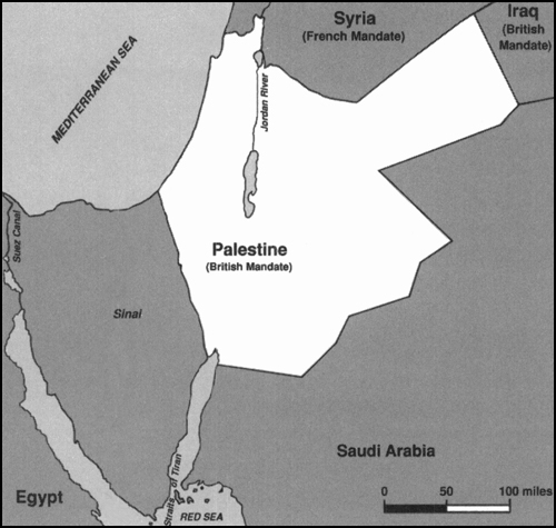
3. 1920 The Jewish National Home Under British Administration
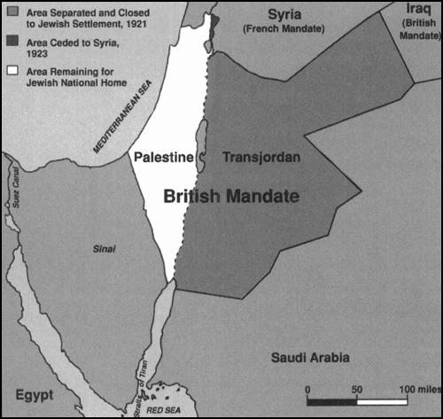
4. 1922 The Jewish National Home After Creation of Transjordan
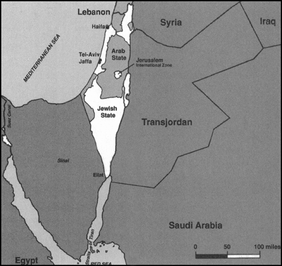
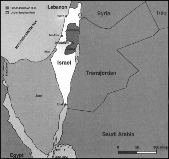
6. 1949 Armistice Lines After War of Independence
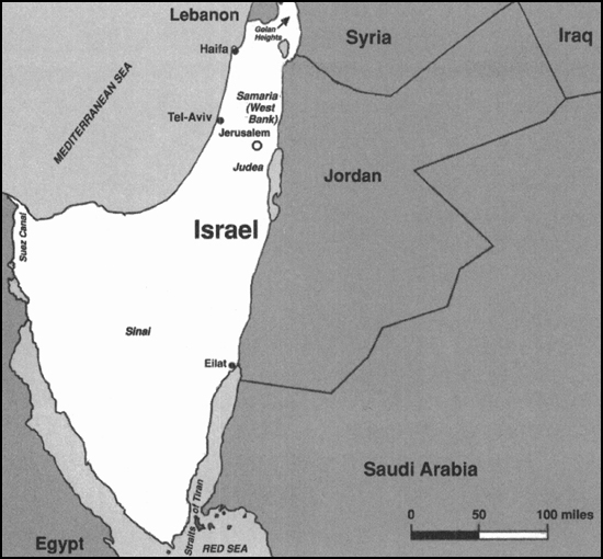
7. 1967 Armistice Lines After Six Day War
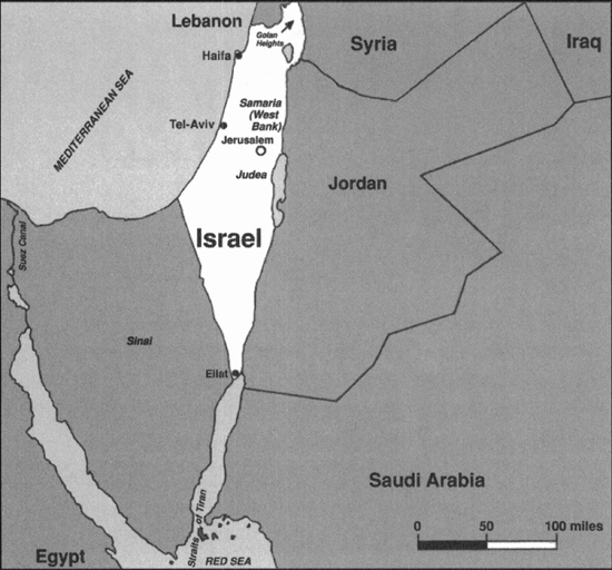
8. 1992 Israel Before the Oslo Accords