Philadelphia's Lost Waterfront (7 page)
Read Philadelphia's Lost Waterfront Online
Authors: Harry Kyriakodis

The 1680s caves along the Delaware River, as imagined by painter William Breton. It is hardly likely that the caves were so uniform in size and so regularly spaced apart.
The Library Company of Philadelphia
.
Ultimately, the forbidden grottos emptied. Some were filled in, while others became part of the basements of houses and stores that were built between Front and Water Streets, right on top of the caves. (The width of the strip of ground between Front and Water from Pegg's Run to Pine Street ranged between twenty-five and forty-one feet but was usually forty feet.) Yet others were converted into arched vaults under the east pavement of Front Street and then connected to newly dug basements.
L
EGACY OF THE
R
IVERFRONT
C
AVES
The buildings on Front between Vine and Callowhill represent the last bank houses of Philadelphia. While the actual structures may have changed, the historic property lines (generally denoted by party walls) in many cases remain unchanged and go back hundreds of years. All these structures were built after 1850, most using the foundations of buildings destroyed in the terrible conflagration on the Philadelphia waterfront that year (discussed in
chapter seven
).
But their basementsâsome under Front Street's east sidewalkâmay date back to the riverbank caves dug out by courageous Quakers in the 1680s. It is fortunate that a group of urban pioneers came to the block in the 1970s and resuscitated what had been a row of derelict storefronts and warehouses. In doing so, they preserved what may be the oldest man-made (or muskrat-made?) things in Philadelphia. Today's residents use these chambers as storage closets, wine cellars and exercise rooms.
In short, Front Street between Vine and Callowhill corresponds to the last unbroken segment of the Delaware River shoreline since William Penn's time. It's a remnant of Philadelphia's waterfront that has not been devastated by the forces of commerce, industry and transportation.
And what a narrow escape this block hadânot once, but twice! It eluded its demise for the Delaware Expressway in the 1970s and then dodged another bullet when the Vine Street Expressway (I-676/U.S. 30) connected to I-95 in the 1980s. Interstate 676 opened in 1991 after years of planning, controversy and construction. Its high-flying ramps did away with many city blocks to the west.
6
F
RONT
S
TREET
P
ENNSYLVANIA
'
S
F
IRST
S
TREET AND A
K
INGLY
H
IGHWAY
Front Street's initial name was “Delaware Front Street,” and it was called that well into the 1800s. (A Schuylkill Front Street was planned for the Schuylkill River's east bank; it wound up as Twenty-second Street.) Front Street takes the place of what could or should be “First Street” in Philadelphia, just as Broad Street takes the place of “Fourteenth Street.”
Laid out atop the Delaware's western embankment when Penn's settlement was platted, Front Street was the first street surveyed and built in Pennsylvania. It hugged the river north and south of Philadelphia and became the town's principal thoroughfare during and after the colonial period.
Delaware Front Street was first a residential street with commanding houses facing the river from its western side. It then turned into a commercial corridor with shops, storehouses and boardinghouses. “Front street was the former great street for all kinds of goods by wholesale,” John Watson stated.
T
HE
K
ING
'
S
H
IGHWAY
Front Street was the main road to Pennsylvania settlements along the Delaware, the town of Frankford above all. Revolutionary War armies, both American and British, used it as the primary entrance into Philadelphia from the north. Right before the Battle of Brandywine, the Continental army marched into the city via Front and then turned west onto Chestnut Street to head out of town. The only way to get into or out of Philadelphia during the city's 1777â78 occupation was to pass through the military post at Front and Noble.
All this stems from Front Street being part of the King's Highway, a road that followed an old Indian trail along the river's west bank from New Castle, Delaware, to the falls of the Delaware at Trenton, New Jersey. The Provincial Council of Pennsylvania ordered construction of this, the first major highway in Pennsylvania, in 1686.
The King's Highway (aka Kingshighway) reached New York City via central New Jersey by 1756, thus creating the key colonial link between Philadelphia and New York. It later became the first direct stagecoach route between the two cities and reduced travel time between them to three days. The King's Highway would eventually extend north and south along the East Coast through several states. It still exists as U.S. Route 13, following closely its original configuration and paralleling Interstate 95.
F
RONT
S
TREET
T
ODAY
The construction of Highway 95 resulted in the crude relocation and narrowing of Front Street from Race to Arch and its elimination between Vine and Race. This was a callous act to inflict on a historic street that had once been so critical to Philadelphia as a whole, as well as its bygone settlers and merchants and the great William Penn personally.
Front Street north of Vine does retain some of its early appearance, old-time Belgian blocks and all. It even rises and falls a bit from Vine to Spring Garden, especially as it heads past the former location of Pegg's Run. This is a manifestation, to this day, of the rolling terrain of the original high bluff on the Delaware River's edge. Front Street south of Arch is paved with asphalt, but it, too, undulates, particularly as it approaches where Dock Creek used to be.
Since 2000, several new or rehabbed apartment and condominium complexes have cropped up on the west side of Front Street between Arch and Walnut. The modern high-rises near Walnut Street are out of scale and style with the older buildings of Old City and Society Hill Philadelphia, but they offer terrific views of the Delaware and exemplify the renewed allure of Front Street as a residential address.
7
V
INE TO
R
ACE
A C
ALAMITOUS
B
LAZE AND A
C
OLOSSAL
B
RIDGE
To reiterate, Vine Street was originally called Valley Street since a ravine dipped toward the Delaware in this vicinity.
W
ILLIAM
R
USH
'
S
S
TUDIO
The studio of William Rush (1756â1833) was once on the west side of Front Street between Vine and Race Streets. The son of a ship's carpenter, he was the first native-born sculptor in America and is acclaimed as the “Father of American Sculpture.”
Rush began his career as a maker of figureheads for ships, which is doubtlessly why he set up shop so close to the Delaware. Usually nine feet tall, his figureheads were the first to give an idea of life and motion to that type of work. His carvings were always wood; he never worked with stone. Rush evolved from a carver of figureheads into the creator of the first monumental American sculptures,
Comedy
and
Tragedy
(1808).
William Rush's concern for civic improvement and his work on public buildings anticipated the direction public art would take in America. His workhouse is gone, lost in the fire described below. Even the block of Front Street on which his shop stood is gone, that locale having been taken over for I-95.
G
REAT
C
ONFLAGRATION OF
1850
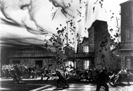
The spectacular waterfront conflagration on July 9, 1850, was the first great fire in Philadelphia's history and the city's most destructive inferno during the nineteenth century. It started at a five-story warehouse on the east side of Water Street, between Vine and Race, at what is approximately 237 North Water these days.
The fire began when pressed hay stored in an upper floor of the storehouse somehow combusted. This itself did not cause much alarm, but a number of violent explosions of saltpeterâstored in the warehouse's basementâspread the fire. Burning hay and flaming embers from the blown-up building flew in all directions. Summer winds conveyed bits of smoldering sulfur (stored in an adjoining storehouse) all the way to Broad Street.
Very quickly, the ensuing fire reached southward to Race Street, westward to Second and northward past Callowhill. People who lived close by packed their things and prepared for a sudden evacuation. The city was at risk of a cataclysm that night. Mass confusion prevailed. The light of the fire was seen for thirty miles around.

An exciting print: “The Great Conflagration in Philadelphia on Tuesday, July 9
th
, 1850.”
Library of Congress
.
News of the blaze was telegraphed across the United States and was even later reported in Great Britain. More than one hundred firemen from New York City, Newark, Wilmington and Baltimore arrived by express train to relieve Philadelphia firefighters who had became exhausted by their exertions and the heat. This was probably the first American disaster in which technologyâtelegraphs and trainsâwere employed.
The fire happened a few years before the 1854 Consolidation of Philadelphia, so the congested commercial area was partly outside the city's original northern limit at Vine Street. Half of the zone of devastation was thus in Northern Liberties.
The inferno was subdued sometime during the night. At least twenty-eight lives were lost (accounts vary), including some killed in the street and in adjacent buildings as a consequence of the initial explosion. Others were trampled in the chaos. Yet others drowned in the Delaware River from the shock of the explosion or from purposefully jumping into the river to flee the calamity. Several firemen died, too.
Newspaper articles reported that 367 buildings were reduced to ashes within some eighteen acres. Roughly 300 of the burned structures were small row homes, leaving dozens of working-class families homeless. In a fairly uncommon civic action in that era, the Philadelphia City Councils appropriated $10,000 for the relief of survivors, and the Commissioners of Northern Liberties did the same. Local citizens also contributed some $31,000 to help the injured victims.
The city block that was ground zero of the explosion and fire was rebuilt and resumed being as overcrowded as before. An empty lot now occupies the block. Plans for a condominium development there fell through, but it seems likely that this lot will one day be used for residential or recreational purposes, given its favorable location.
T
HE
D
ELAWARE
R
IVER
(B
ENJAMIN
F
RANKLIN
) B
RIDGE
Leaders from Pennsylvania and New Jersey had talked for years about constructing a bridge or tunnel between Philadelphia and Camden. In 1919, legislation was passed in both states to build a bridge across the Delaware River. The study of right of ways proposed for the span entailed one of the first traffic surveys in America. Potential Philadelphia endpoints included Washington Square, Sixth and Spring Garden and even Third and Market.

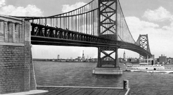
The Benjamin Franklin Bridge, looking toward Philadelphia. This large undated postcard was produced for the Sesquicentennial International Exposition of 1926.
Author's collection
.
Construction of the Delaware River Bridge began on January 6, 1922, and it opened on July 1, 1926, just in time for the nation's Sesquicentennial Exposition celebration in Philadelphia. The bridge cost $37 million and has been characterized as the “first distinctly modern suspension bridge built on a grand scale.” It was an instant success, attracting thirty-five thousand vehicles a day to cross the Delaware at twenty-five cents a passage.
The bridge is 128 feet wide and 8,291 feet from portal to portalâ9,620 feet when the plazas are included. The structure's 1,750 foot-long center span was the world's longest single suspension span for a while. Its towers rise nearly 400 feet above the river. Over twenty-five thousand miles of cable were used in two main cables, each thirty inches in diameter.
