X and the City: Modeling Aspects of Urban Life (4 page)
Read X and the City: Modeling Aspects of Urban Life Online
Authors: John A. Adam

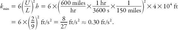
and the corresponding acceleration component is.
Since
a
y
is an increasing function of
x
, its extreme values are ±6
U
2
h/L
2
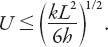
, occurring at the endpoints of the descent path (the minimum at the start and the maximum at the finish of the descent). Therefore from condition (iii) above,
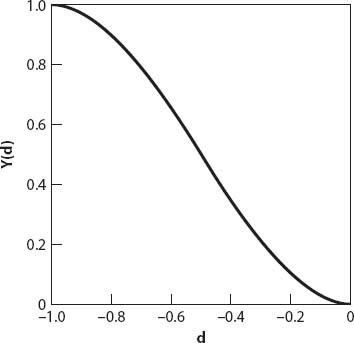
Figure 2.1. The flight path
Y(d)
.
This result can provide useful information depending on the type of flight and runway size. For transcontinental or transatlantic flights aboard a 747 jet (let’s suppose the latter), we rewrite the above inequality as
Typically, both
U
and
h
are “large” and
k
is “small,” so this implies that
L
must be relatively large (compared with smaller airplanes). Suppose that
U
= 600 mph,
h
= 40,000 ft, and
L
= 150 miles. Then a further rearrangement of (2.4) gives a lower bound for
k
of approximately (in ft/s
2
)
If, on the other hand, we find ourselves on a “puddle jumper” flight, then
Therefore we expect
L
and
k
to be smaller than in the example, while
h
is still relatively large, so not surprisingly the airspeed will be correspondingly lower. Nevertheless, there are exceptions. Barshinger (1992) [
5
] relates his experience landing at Lake Tahoe. As the plane crossed the last peak of the 11000 ft Sierra Nevada Mountains, the airport was only twenty miles away. For these values of
h
and
L
and an airspeed of 175 mph,
k
≈ 0.39 ft/s
2
, 30% larger than on the transatlantic flight!
Question:
Can a similar analysis be carried out when equation (2.1) is replaced by
y
=
A
+
B
tanh
C
(
x
−
D
) (where
A
,
B
,
C
, and
D
are constants)?
Well, I landed safely, and after checking in to my hotel I decided to take a walk, map in hand. Being directionally challenged at the best of times, even with a map, pretty soon I was lost, and it didn’t seem to help much, because every place I wanted to go seemed to be right at the edge of the map, or on the well-worn fold! Getting irritated, I had a question to ask of no one in particular . . .
=
A
: THE MAP
Why is the place I’m looking for on a map
so often
at its boundary? Let’s investigate. Consider first a map consisting of a rectangular sheet of relative dimensions 1 and
b
< 1, including a margin of width
a
<
b
. The area of the sheet is
b
square units and the relative area
A
of the margin is
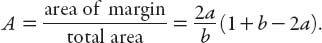
For a square map with unit side,
A
(
a
) = 4
a
(1 −
a
).
A
has a maximum at
a
= 0.5; the map is all margin! More realistically, if
a
= 0.1,
A
= 0.36 or 36%, more than a third of the whole area is margin! Furthermore, the margin is 9/16 or about 56% of the map area!
Given a road atlas of the same relative dimensions, for the two pages combined,
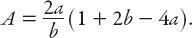
Taking
b
= 1 and
a
= 0.1 as before,
A
= 0.52, less than half the sheet is map!
=
$$
: BY TAXI
Without finding my destination using the map, I decided to hail a taxi, but it seemed as if we drove forever. I’m sure we passed some places twice. Perhaps the driver took me on a world trip, which leads me to the following question . . .
Question:
How many taxi rides would it take to circle the Earth?
Perhaps only one, if the driver is willing . . . more generally, we need to estimate the average length of a taxi ride and the circumference of the Earth. Let’s start with the Earth. We might remember the circumference. If not, we might remember that the radius of the Earth is about 4000 miles and then calculate the circumference using
C
= 2
πr
. On the other hand, if we know that it is about 3000 miles from New York to Los Angeles and that they are three time zones apart, then 24 time zones will give you a circumference of 24,000 miles. This does seem a little more obscure, though.
Now let’s consider a typical taxi ride. To go from downtown to Manhattan’s Upper East (or West) Side is about 80 blocks or four miles [
6
]. Alternatively, the shortest ride will be about a mile and the longest will be about ten miles, so we can take the geometric mean
1
and estimate three miles. At three miles per ride, you will need about 8,000 taxi rides to circumnavigate the globe. Hey, that’s about one per squirrel! (This is a teaser to keep you reading; see
Chapter 6
.) At $2.50 for the first 1/5 mile and $0.40 for each additional 1/5 mile, that
will cost you $20,000 plus $45,000 = $65,000 in cab fare (plus tips and waiting time). By the way: good luck hailing a cab in the middle of the Atlantic.
Since we’ll be talking about driving in the city, and either flying or driving to get there, let’s also apply these principles in that context and do some elementary “risk analysis.”
Question:
What is the risk (in the U.S.) of dying per mile traveled in a car? [
7
]
Okay: how far do Americans drive in a year? Warranties for 5 yr/60,000 miles are very common these days, so it’s clear that car dealerships reckon that a typical domestic vehicle is driven about 12,000 miles per year on average. Alternatively, one can count the miles covered per week, halve it, and multiply by 100 (why?) Now there are a little over 300 million (3 × 10
8
) people in the U.S., about half of whom drive (and maybe only half of those drive well), so the total mileage per year is about 1.5 × 10
8
× 1.2 × 10
4
≈ 2 × 10
12
miles. As is readily checked, there are about 4 × 10
4
deaths due to car accidents in the U.S. each year, so the risk of death per mile is 4 × 10
4
÷ 2 × 10
12
= 2 × 10
−8
deaths/mile!