The Egypt Code (39 page)
Authors: Robert Bauval

In any case, what is really interesting for us here is that the orientation errors of the pyramids form a set of experimental data from which a precessional effect can be deduced. Whatever the reason, the effect is absolutely transferable exactly in the case of the most huge and perfectly built pyramids, namely Giza 1 and Giza 2. However one can speculate, for instance, that the relative orientation of the Giza 3 pyramid could have been compared with that of Giza 2 and therefore the precessional effect leading to a deviation of 18.4′, i.e. about ⅓ of a degree, be observed. In any case, I want to stress that the astronomically anchored data coming from Giza (orientation of air-shafts and pyramids) as well as the many astronomical references present in the Pyramid Texts do show beyond any possible doubt that astronomy was present in the Old Kingdom as a fundamental part of thinking (religion and knowledge).
3.2 MaltaStrangely enough, the Mediterranean archipelago of Malta (composed of the isles Malta, Gozo and Comino) has a short history which, according to all sources, begins only in the fifth millennium BC when Malta was first colonized by humans (Trump 1991, 2002). However, after only 1500 years, with the beginning of the so called Temples Period (about 3500-2500 BC) Malta’s civilization became the first to construct megalithic buildings (only a few megalithic tombs are dated before this period, like Kintraw in Britain, while the first stone phases of Stonehenge and of other megalithic monuments - i.e. not tombs - belong to the first half of the third millennium).
In the megalithic phase more than 40 temples were constructed. Actually the world ‘temple’ should be put in quotation marks because it is far from being clear which was the real function of the buildings. However traces of a worship for a “mother goddess” deity are evident. The temples are composed of buildings (up to three, corresponding to subsequent phases and numerated accordingly) which all have an external masonry of ovoid shape while the internal plan is composed of a subsequent series of ‘lobes’ constructed along the same axis and ending with an ‘apse’. The internal ‘lobes’ probably define the shape of the “Mother Goddess”.
The best preserved temples are
Ggantija
, the place of the giants, in Gozo, and
Hagar Qim
,
Mnajdra
and
Tarxien
in Malta. The temples show a clear interest of the builders for celestial phenomena. This interest is absolutely evident in Mnajdra II, which is a solar calendar built in stone: the axis is aligned to due east, and the ‘altar’ stones are put in such a way that one can keep track of the yearly movement of the sun from the far left to the far right of the ‘apse’. All other Malta temples have axes oriented to the south, and the orientation is to the south of all directions related to sun and moon (i.e. winter solstice sunrise and southern moon major standstill). Due to the work by Michael Hoskin and collaborators and by Klaus Albrecht however, today we have a quite clear picture of the astronomical orientation of Malta temples. As a key example, I will discuss Ggantjia.
The two temples of Ggantjia correspond to two subsequent phases, and the second one is oriented further south with respect to the first. Both exhibit a solar orientation in the left altar, which is oriented to winter solstice sunrise (Albrecht 2001) and both exhibit a stellar orientation in the main axis, which is oriented towards the asterism composed by the Southern Cross and the two bright stars of Centaurus (remember that it is only in the last few centuries that the Southern Cross has been identified formally as a constellation, and that ancient constellation by no means should coincide with ours. In any case, ours belongs to the mesopotamic-greek tradition) (Hoskin 2001).

Fig. 5
Plan of the Ggantija temples
Plan of the Ggantija temples
Although the discoverer of the solar orientation, Albrecht, states that the stellar hypothesis is not viable, I do instead think that this is a quite clear example in which
both
solar and stellar orientations were realized. The problem was, of course, that while the solar one was to remain accurate for centuries and centuries, the stellar one was changing due to precession. It is therefore strongly tempting to conclude that they were
obliged
to construct the second temple to match the movement due south of the raising of the Crux-Centaurus asterism.
3.3 Majorcaboth
solar and stellar orientations were realized. The problem was, of course, that while the solar one was to remain accurate for centuries and centuries, the stellar one was changing due to precession. It is therefore strongly tempting to conclude that they were
obliged
to construct the second temple to match the movement due south of the raising of the Crux-Centaurus asterism.
The Balearic isles of Minorca and Majorca were, about one thousand years after Malta and thus during the Bronze Age, inhabited by megalithic sky-watchers. The so called sanctuaries of the two islands, including the famous Minorcan
Taulas,
megalithic structures composed by two monoliths disposed as a giant ‘T’, were oriented due south to the same asterisms mentioned before, composed by the Southern Cross and the two bright stars of Centaurus (Hoskin 2001).
Taulas,
megalithic structures composed by two monoliths disposed as a giant ‘T’, were oriented due south to the same asterisms mentioned before, composed by the Southern Cross and the two bright stars of Centaurus (Hoskin 2001).
We are interested here especially in one of the sanctuaries, called
Son Mas
, in Majorca.
Son Mas
, in Majorca.
When the Hoskin group studied the site, it became clear that it was oriented to the low arc in the southern sky that the asterism Crux-Centaurus was following at the end of a valley, in about 2000 BC However the lower part of this asterism would have become invisible due to precession in about 1700 BC. Therefore, if the site was really connected with astronomical observations, it should have been abandoned around that date. Hoskin was not, at that time, aware that a team headed by Mark Van Strydonck of the Belgian Royal Institute of Cultural Heritage was carbon-dating samples from the same site, and was actually wondering why the site was abandoned exactly in that period!
This is thus a very interesting example of the way in which Archaeo-astronomy can act as a predictive science. What is especially interesting for us here is, of course, that it is clear that an astronomical alignment showed that ‘something was happening’ in the southern sky in Majorca and induced the people to abandon the site.
3.4 The Medicine wheelsThe so called
Medicine Wheels
are stone monuments composed of a central cairn of stones connected by radial rows to an external circle and other cairns. Most wheels can be found in Alberta, Canada, but the most famous of them, the Big Horn wheel, lies near the Medicine Mountain in Wyoming and the name of the family comes from this wheel.
There are several typologies of wheels, but some of them have been indubitably linked to astronomical observations. The first wheel to be identified with an astronomical observatory is the Big Horn one. A solar physicist, John Eddy, recognised that the small cairns which are distributed on the external circle of the wheel serve as astronomical outpost for many alignments. The alignments recognised by Eddy are at the summer solstice and at the heliacal rising of Aldebaran, Rigel and Sirius (Eddy 1974, 1977). The window of validity of such alignments (which is of the order of three centuries due to precession) holds for the last three centuries, and indeed independent archaeological data give to the Big Horn an age of 250 years.
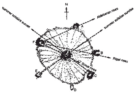
Fig. 6
The astronomical alignments of the Big Horn Medicine Wheel discovered by Eddy.
The astronomical alignments of the Big Horn Medicine Wheel discovered by Eddy.
Eddy’s interpretation received a wonderful confirmation after the archaeological study of another wheel, the Moose Mountain Medicine wheel. This wheel in fact has alignments towards the same targets, but the window of validity is completely different, and lies around the last centuries BC. When archaeologists Tom and Alice Kecoe obtained C- 14 datable samples from the site, they were able to confirm the ‘astronomically predicted’ age of the monument, showing a constant interest of the (at yet unknown) wheel builders for the same astronomical objects in the courses of two millennia: another wonderful example of Archaeoastronomy as a predictive science (actually the wheels astronomical tradition is much older than this: the Majorville Wheel in Alberta was used for solar observations already in 2500 BC).
What is especially interesting for us here is the missing “D” alignment, which was later individuated by Robinson (1980) both at Big Horn and at Moose Mountain. Robinson discovered this direction to be aligned with the rising of Fomalhaut, a star of the constellation Pisces Australis (not to be confused with the zodiacal constellation Pisces). The window of validity of this alignment is however
shifted in time
by some centuries with respect to Eddy’s estimates for Moose Mountain. This looks strange, but the radial line of stones is curved along its length. It looks as if the line was originally pointing more westerly and was then curved
in order to follow the precessional shift of the point of rising of the star.
A similar deviation is shown by the cairn pointing to Sirius, another southerly star more quickly affected by the precessional cycle than Aldebaran and Rigel.
Thus the Moose Mountain Medicine Wheel strongly candidates as a place where tenacious astronomers discovered a precessional effect.
3.5 Teutihuacan and the “17 degree” familyWhile, as we have seen, we have a very clear picture of the way in which the Maya recorded their astronomical observations, the same cannot be said of other Mesoamerica cultures. We practically do not know anything about the astronomy of the so called mother culture of Mesoamerica, the Olmecs, and we do not have written records coming from the most important culture of the Mexico valley, which flourished during the pre-classic Maya period, roughly between the second and the sixth century BC, and which influenced all subsequent civilization in central Mexico, including the Toltecs and, finally, the Aztecs. I am speaking, of course, of the place which the Aztecs themselves considered as the city of the gods, Teutihuacan.
Teutihuacan lies not far from Mexico city, and is still today a huge town which, at the moment of maximum urbanization, should have reached more than 125,000 inhabitants. The city was planned under a rigid project which aimed to
replicate
the landscape. This is evident from the fact that the main two buildings of the town, the so called Sun pyramid and Moon pyramid (these are late denominations, as no connection with the sun and moon has ever been proved) are disposed in such a way to be a ‘copy’ an image of the two mountains which lie respectively behind, the Cerro Gordo and the Cerro Patlachique.
The town was planned and constructed on a ‘cardinal grid’ based on two axes, a ‘T-north’ axis oriented 15.5 degree east of north, and a ‘T-east’ axis oriented 16.5 degrees south of east. This was by no means due to geomorphologic reasons (it suffices indeed to think that the river crossing the town was canalised to conform to the grid). Teutihuacan ‘cardinal directions’ are thus rotated with respect to the ‘true’ cardinal directions and tilted one further degree from each other for symbolic reasons. Astronomy plays here a fundamental role, since the most reasonable explanation is the following:
The T-east orientation is a solar orientation. It is too close to east to signal any special event in the motion of the sun at the horizon (solstice and days of zenit passage) however the sun sets at T-west on 13 August and 29 April, and these two dates are separated by 260 days. It is well known that the so called sacred calendar of Mesoamerica (well documented by the Maya, but probably coming from the very early civilization and codified around 4 BC) was composed of 260 days. The origin should be the passage of the sun at zenith, which of course depends on latitude and occurred in those two dates at the latitude of the pre-classic site of Izapa (see Aveni 2001 for a complete discussion). Thus, the T-east orientation was probably a reminder for the sacred calendar of solar origin. What is especially interesting for us here is however the T-north orientation, because it is almost certainly a stellar one.
Other books
Dagger: A Devil's Hellions Romance by Lauren Hunt
Starf*cker: a Meme-oir by Matthew Rettenmund
Goldie [Pyrate's Treasure 1] (Siren Publishing Classic) by McKenzie, Cooper
Love's Long Journey (Love Comes Softly Series #3) by Janette Oke
Encore by Monique Raphel High
Before I Sleep by Ray Whitrod
Barefoot by Ruth Patterson
Black Cat Crossing by Kay Finch