The Attacking Ocean (30 page)
Read The Attacking Ocean Online
Authors: Brian Fagan
Tags: #The Past, #Present, #and Future of Rising Sea Levels

Figure 12.4
Malé, capital of the Maldive Islands. J. W. Alker. © Imagebroker/Alamy.
Herein lies the dilemma of small islands: Their options are far more limited than people on low-lying coastal plains, who at least have more space. There are no utopian solutions for people living in the midst of open ocean where swells can build over thousands of kilometers. It is
not as if they are living on lakes, like Lake Titicaca, where the Uros people used to live in forty fishing villages fashioned from totora reeds that float in the middle of the lake. Most of the Uros now dwell on the mainland, free of the constant labor of keeping their homes afloat.
Small island governments are vociferous about their plight, often blaming industrialized countries for global warming and rising sea levels, and pushing for financial assistance to combat their impending inundation. Such lobbying seems to have fallen on largely deaf ears, for the problems of remote island nations are hardly a high priority in the international realm, especially when the solutions involve long-term thinking that is often unimaginable to politicians obsessed with election cycles. However, as sea levels slowly rise, extreme weather events with their storm surges become more frequent, and ever-lower islands face death sentences from unpredictable tsunamis, the prospect of large-scale out-migration must be considered just as in Bangladesh.
The crisis of barrier islands and remote atolls unfolds at a time when the world lacks any international policies for coping with climatic refugees from small island nations, let alone people in river deltas and on mainland shores. Their plight, still coming into urgent focus, is a global challenge that cries out for measured, international policies to confront the problem head-on before thousands of disoriented, fearful, and hungry migrants arrive on foreign shores where they are unwelcome. For the first time in history, we face a challenge of forced involuntary migration for millions of people, triggered not by ruthless kings, conquering armies, or prosecuting fanatics, but by the natural forces of our capricious world.
13
“The Crookedest River in the World”
Mark Twain memorably observed that “the Mississippi … is not a commonplace river, but on the contrary is in all ways remarkable.” He also called it “the crookedest river in the world, since in one part of its journey it uses up one thousand three hundred miles to cover the same distance that the crow would fly in six hundred and seventy-five.”
1
This is a stupendous river by any standards, 3,779 kilometers long, with a huge triangular drainage area that covers about 40 percent of the United States, the third-largest river drainage in the world, exceeded only by the Amazon and the Congo. The river rises in Lake Itasca, Minnesota, and then flows through the heart of the Midwest. The Missouri River with its vast silt load, the Great Muddy, which drains the Great Plains, joins the Mississippi at St. Louis, the Ohio River at Cairo, Illinois. Below Cairo, the river flows through a wide, low valley, once a bay of the Gulf of Mexico, now filled with sediment. Today 966 kilometers downstream the Mississippi joins the Gulf. The river channel meanders over the low-lying plain, often contained between natural levees formed by flood sediments.
Through a natural process known as avulsion, literally delta switching, the river has meandered back and forth across the flat landscape of the Lower Mississippi valley ever since sea levels climbed in the Gulf of Mexico after the Ice Age. The river’s gradient shallows with the ocean’s rise, the flow slows, and the silt load sinks to form lobes of a huge delta in a regime that changed little for thousands of years—until humans started controlling the Mississippi. Sediment builds up; a channel becomes clogged; the river shifts course to a steeper route downstream. Meanwhile the abandoned channel receives less water and becomes a bayou. A major channel shift triggered by an unusually severe spring flood takes place about every thousand years. The last one would have inundated maize fields on the floodplain, but the ancient farmers, hunters, and fisherfolk on the flatlands and among the bayous would have adapted to the shift without trouble. Today’s river is long overdue for a dramatic channel shift, most likely down the Atchafalaya Basin or through Lake Pontchartrain near New Orleans. This time the human and economic stakes are very high indeed, with almost unthinkable consequences for cities like New Orleans and Baton Rouge. Only massive humanly constructed flood control works stand between millions of people and disaster from upstream.
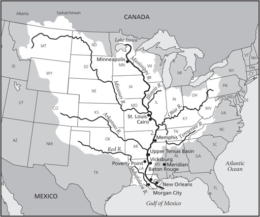
Figure 13.1
Map showing locations in
chapter 13
.
Most of the Lower Mississippi’s water comes from the Ohio River and from downstream tributaries like the Arkansas and Red Rivers,
only 15 percent from its own upper reaches. The Missouri contributes considerably less water, but massive quantities of silt, both of which flow down the Lower Mississippi. All these sources make for a complex flood regimen, especially when all major tributaries overflow at the same time. Such events resonate in historical memory. The Great Mississippi Flood of 1927 produced overflows so severe that the river reached a width of ninety-seven kilometers. On April 15, 385 millimeters of rain fell on New Orleans, covering parts of the city with more than two meters of water. The Flood Control Act of 1928 authorized the Army Corps of Engineers to construct the longest levee system in the world. With the new levees came at least some protection from raging floods, but also a new ever-present threat of highly destructive breaks in the defense walls caused by floods and hurricane-induced sea surges. For all the additional protection, many communities in the shadow of levees were potentially even more vulnerable than before.
THE ROUTINE NEVER changed—enormous flocks of migrating waterfowl flying northward in spring, south in fall, along what is now known as the Mississippi flyway. Thousands of birds would pause to feed and rest at shallow oxbow lakes near the great river. Each spring and fall, the hunters would wait in the reeds at dawn with traps and spears. They would use canoes to drive the birds into narrow defiles in the reeds, where they could be netted, or swim among them with duck decoys on their heads, then grab their unsuspecting prey by the feet from underwater. Back ashore, they preserve the birds by drying and soaking them in oil for later consumption. Storage was critical. Everyone living along the river had experienced food shortages caused by floods that could inundate wide tracts of the floodplain until as late as July.
Between about 4500 and 4000 B.C.E., the Mississippi and its tributaries slowed as sea levels stabilized. Silt from the now more sluggish river accumulated. Backwater swamps and oxbows formed, which proved to be a paradise for hunters camped along their floodplains. Apart from waterfowl, they thrived off fish and mollusks, also plant foods, which abounded, especially the nut harvests of fall. So plentiful
were food supplies that many groups stayed in the same places for most, if not all, the year.
By 2000 B.C.E., the Lower Mississippi had become a complex political and social world. Most people now lived in small base camps, but sometimes clustered around somewhat larger centers, connected to other groups by intricate ties of kin and volatile rivalries. The largest of these centers comes as somewhat of a surprise in a world of hamlets and temporary camps. The great horseshoe-shaped earthworks and mounds of Poverty Point lie on the Macon Ridge in the Mississippi floodplain, near the confluences of six rivers and twenty-five kilometers from the great river itself. Six concentric semicircular earthen ridges divided into segments lie about forty meters apart. Apparently houses lay atop the earthworks, which were about twenty-five meters wide and three meters high, elevated above the surrounding low-lying terrain. To the west, an earthen mound stands more nearly twenty meters high and two hundred meters long. Over five thousand cubic meters of basket-hefted soil went into the Poverty Point earthworks.
2
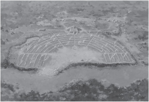
Figure 13.2
The earthworks at Poverty Point, Louisiana. © Martin Pate.
The concentric earthworks came into being in about 1650 B.C.E., surrounded by a network of lesser centers. Long-distance trade routes carrying exotic materials converged here, not only from upstream along the Mississippi, but also from the Arkansas, Red, Ohio, and Tennessee Rivers as well. Together, they formed the nexus of a vast exchange network that handled exotic rocks and minerals such as galena from more than ten sources in the Midwest and Southeast, some of them as far as a thousand kilometers away.
Poverty Point is a huge enigma. How many people lived there? Was this a center where hundreds of visitors gathered for major ceremonies, perhaps on occasions such as the solstices? A person standing on the largest Poverty Point mound can sight the vernal and autumnal equinoxes directly across the center of the earthworks to the east. This is the point where the sun rises on the first days of spring and fall, but whether this was of ritual importance remains a mystery. What is certain, however, is that Poverty Point was at the mercy of river floods and the vagaries of the Mississippi delta downstream.
The great center lies near natural escarpments, close to floodplain swamps, oxbow lakes, and upland hunting grounds. Like societies up and down the major rivers nearby, Poverty Point people were hunters and plant gatherers. They also cultivated a number of native species, such as sunflowers, bottle gourds, and squashes. The floodplain landscapes and their environs produced more than enough food for considerable numbers of people to live permanently in places as large as Poverty Point, but we still know little about them, or of the leaders behind the centers, who must have organized the communal labor needed to erect earthworks and mounds. Poverty Point was a prophetic forerunner of much more elaborate chiefdoms that flourished along the Mississippi and its tributaries a thousand years later. But, after centuries of gradual population growth and extensive long-distance trade, Poverty Point society gradually imploded. The exchange system collapsed after 1000 B.C.E. Three hundred years later Poverty Point was deserted. Everyone had moved away. Trade slowed, settlements were smaller, and any semblance of complex society vanished. One major factor may have been climate change.
Tracking climate change in the Lower Mississippi valley is an exercise in complexity, for riverbank breaks, shifts in large meander belts, and other geological processes resulted in major changes in human settlement, especially between about 1000 and 450 B.C.E. During these centuries, rainfall was higher and temperatures were cooler over wide areas of the world, higher rainfall notably causing increased flooding in the Netherlands, with abandonment of many low-lying areas. We know that cooler and wetter climate pertained in some parts of Minnesota and that there were larger than normal floods along Mississippi tributaries in southwestern Wisconsin. Out in the Gulf of Mexico, the Orca Basin traps sediment from the great river, whose varying size reflects the intensity of ancient floods. At least two flood cycles of unprecedented volume occurred between about 1000 and 550 B.C.E., which introduced large quantities of freshwater into the Gulf. Each of these major cycles lasted for as long as fifty years and must have had major effects on the hydrologic system of the Mississippi River basin. At the same time, between about 900 and 550 B.C.E., many more hurricanes and large storms came ashore along the Gulf Coast. The combined effects of lower temperatures, higher rainfall, and changed atmospheric circulation produced much more flooding along the Mississippi, with resulting serious disruption of daily life among the societies along its banks, perhaps the explanation for a sharp decline in the number of archaeological sites and possibly in human populations in the alluvial portions of the Mississippi River basin as Poverty Point was abandoned.
During the time when Poverty Point prospered, before 1000 B.C.E., the river enjoyed a period of relative geological stability.
3
Around then, the Mississippi channel shifted north of Vicksburg, Mississippi, upstream of Poverty Point, causing westward migrations in river channels downstream, including Joe’s Bayou near Poverty Point, which became a major outlet for the river, just as major flooding affected the region. The floods rendered much of the alluvial plain uninhabitable for long periods of time, sweeping away ponds and sloughs where the people had harvested thousands of fish as floods receded. Fish densities may have plummeted in the now faster-moving water, which may have forced the groups who had relied on the fish harvests to rely more heavily on hunting and plant
foods in the nearby uplands. No longer could people live in permanent settlements; the floods would have disrupted long-distance trade by canoe.