The 12th Planet (48 page)
Authors: Zecharia Sitchin
Tags: #Non-Fiction, #Gnostic Dementia, #Fringe Science, #Retail, #Archaeology, #Ancient Aliens, #History

Enlil's lieutenant would then make a rough sketch—a triangle of waters and mountains on each side, pointing like an arrow toward Sippar. An "X" would mark Nippur, in the center. (Fig. 131)
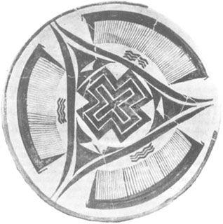
Fig. 131
Incredible as it may seem, this sketch was
not
made by us; the design was drawn on a ceramic object unearthed at Susa, in a stratum dated to about 3200
B.C.
It brings to mind the planisphere that described the flight path and procedures, which was based on 45-degree segments.
The establishment of settlements on Earth by the Nefilim was not a hit-or-miss effort. All the alternatives were studied, all the resources evaluated, all the hazards taken into account; moreover, the settlement plan itself was carefully mapped out so that each site fit into the final pattern, whose purpose was to outline the landing path to Sippar.
No one has previously attempted to see a master plan in the scattered Sumerian settlements. But if we look at the first seven cities ever established, we find that Bad-Tibira, Shuruppak, and Nippur lay on a line running precisely at a 45-degree angle to the Ararat meridian, and that line crossed the meridian exactly at Sippar! The other two cities whose sites are known, Eridu and Larsa, also lay on another straight line that crossed the first line and the Ararat meridian, also at Sippar.
Taking our cue from the ancient sketch, which made Nippur the center of a circle, and drawing concentric circles from Nippur through the various cities, we find that another ancient Sumerian town, Lagash, was located exactly on one of these circles—on a line equidistant from the 45-degree line, like the Eridu–Larsa–Sippar line. The location of Lagash mirrors that of Larsa.
Though the site of LA.RA.AK ("seeing the bright halo") remains unknown, the logical site for it would be at Point 5, since there logically was a City of the Gods there, completing the string of cities on the central flight path at intervals of six
beru:
Bad-Tibira, Shuruppak, Nippur, Larak, Sippar. (Fig. 132)
The two outside lines, flanking the central line running through Nippur, lay 6 degrees on each side of it, acting as southwest and northeast outlines of the central flight path. Appropriately, the name LA.AR.SA meant "seeing the red light"; and LA.AG.ASH meant "seeing the halo at six." The cities along each line were indeed six
beru
(approximately sixty kilometers, or thirty-seven miles) from each other.
This, we believe, was the master plan of the Nefilim. Having selected the best location for their spaceport (Sippar), they laid out the other settlements in a pattern outlining the vital flight path to it. In the center they placed Nippur, where the "bond Heaven–Earth" was located.
•
Neither the original Cities of the Gods nor their remains can ever be seen by man again—they were all destroyed by the Deluge that later swept over Earth. But we can learn much about them because it was the sacred duty of Mesopotamian kings continuously to rebuild the sacred precincts in exactly the same spot and according to the original plans. The rebuilders stressed their scrupulous adherence to the original plans in their dedication inscriptions, as this one (uncovered by Layard) stated:
The everlasting ground plan,
that which for the future
the construction determined
[I have followed].
It is the one which bears
the drawings from the Olden Times
and the writing of the Upper Heaven.
If Lagash, as we suggest, was one of the cities that served as a landing beacon, then much of the information provided by Gudea in the third millennium
B.C.
makes sense. He wrote that when Ninurta instructed him to rebuild the sacred precinct, an accompanying god gave him the architectural plans (drawn on a stone tablet), and a goddess (who had "travelled between Heaven and Earth" in her "chamber") showed him a celestial map and instructed him on the astronomical alignments of the structure.
In addition to the "divine black bird," the god's "terrible eye" ("the great beam that subdues the world to its power") and the "world controller" (whose sound could "reverberate all over") were installed in the sacred precinct. Finally, when the structure was complete, the "emblem of Utu" was raised upon it, facing "toward the rising place of Utu"—toward the spaceport at Sippar. All these beaming objects were important to the spaceport's operation, for Utu himself "came forth joyfully" to inspect the installations when completed.
Early Sumerian depictions frequently show massive structures, built in earliest times of reeds and wood, standing in fields among grazing cattle. The current assumption that these were stables for cattle is contradicted by the pillars that are invariably shown protruding from the roofs of such structures. (Fig. 133a)
The pillars' purpose, as one can see, was to support one or more pairs of "rings," whose function is unstated. But although these structures were erected in the fields, one must question whether they were built to shelter cattle. The Sumerian pictographs (Fig. 133b) depict the word DUR, or TUR (meaning "abode," "gathering place"), by drawings that undoubtedly represent the same structures shown on the cylinder seals; but they make clear that the main feature of the structure was not the "huts" but the antenna tower. Similar pillars with "rings" were posted at temple entrances, within the sacred precincts of the gods, and not only out in the countryside. (Fig. 133c)
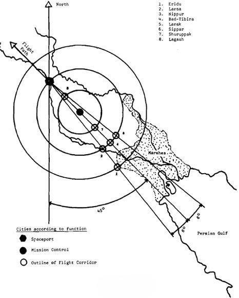
Fig. 132
Were these objects antennas attached to broadcasting equipment? Were the pairs of rings radar emitters, placed in the fields to guide the incoming shuttlecraft? Were the eyelike pillars scanning devices, the "all-seeing eyes" of the gods of which many texts have spoken?
We know that the equipment to which these various devices were connected was portable, for some Sumerian seals depict boxlike "divine objects" being transported by boat or mounted on pack animals, which carried the objects farther inland once the boats had docked. (Fig. 134)
These "black boxes," when we see what they looked like, bring to mind the Ark of the Covenant built by Moses under God's instructions. The chest was to be made of wood, overlaid with gold both inside and outside—two electricity-conducting surfaces were insulated by the wood between them. A
kapporeth,
also made of gold, was to. be placed above the chest and held up by two cherubim cast of solid gold. The nature of the
kapporeth
(meaning, scholars speculate, "covering") is not clear; but this verse from Exodus suggests its purpose: "And I will address thee from above the Kapporeth, from between the two Cberubim."
The implication that the Ark of the Covenant was principally a communications box, electrically operated, is enhanced by the instructions concerning its portability. It was to be carried by means of wooden staffs passed through four golden rings. No one was to touch the chest proper; and when one Israelite did touch it, he was killed instantly—as if by a charge of high-voltage electricity.
Such apparently supernatural equipment—which made it possible to communicate with a deity though the deity was physically somewhere else-became objects of veneration, "sacred cult symbols." Temples at Lagash, Ur, Mari, and other ancient sites included among their devotional objects "eye idols." The most outstanding example was found at an "eye temple" at Tell Brak, in northwestern Mesopotamia. This fourth-millennium
B.C.
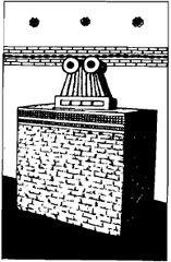
temple was so named not only because hundreds of "eye" symbols were unearthed there but mainly because the temple's inner sanctum had only one altar, on which a huge stone "double-eye" symbol was displayed. (Fig. 135)
In all probability, it was a simulation of the actual divine object—Ninurta's "terrible eye," or the one at Enlil's Mission Control Center at Nippur, about which the ancient scribe reported: "His raised Eye scans the land.... His raised Beam searches the land."
The flat plain of Mesopotamia necessitated, it seems, the artificial raising of platforms on which the space-related equipment was to be placed. Texts and pictorial depictions leave no doubt that the structures ranged from the earliest field huts to the later staged platforms, reached by staircases and sloped ramps that led from a broad lower stage to a narrower upper one, and so on. At the top of the ziggurat an actual residence for the god was built, surrounded by a flat, walled courtyard to house his "bird" and "weapons." A ziggurat depicted on a cylinder seal not only shows the customary stage-upon-stage construction, it also has two "ring antennas" whose height appears to have equaled three stages. (Fig. 136)
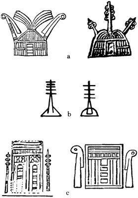
Fig. 133
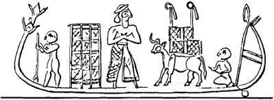
Fig. 134
