Read In the Footsteps of Lewis and Clark Online
Authors: Wallace G. Lewis
In the Footsteps of Lewis and Clark (11 page)

Almost at the site of Fort Peck Dam, the river runs close to U.S. Highway 2, once known as Roosevelt International Highway. At Big Muddy Creek the expedition moved along the southern boundary of the Fort Peck Indian Reservation and passed the towns of Poplar and Wolf Point. On May 2, near Poplar, an inch of snow fell, coating flowers and leafed-out trees. Clark remarked that it was “a verry extroadernaley Climate.” [IV, 101] On May 8, south of Glasgow, they encountered the Milk, the “River Which Scolds All Others.” It flows out of Glacier National Park and into southern Alberta before sweeping back into Montana. Beyond the Milk River, which U.S. 2 turns northwest to follow, lay a 180-mile portion of the river now covered by Fort Peck Lake. In the vicinity of Sticklodge Creek on May 14, the group had one of its most disconcerting encounters with a grizzly bear. That evening some of the men spotted a large brown bear lying in the open ground about 300 paces from the river, and six of them set out to shoot it. They were able to sneak up fairly close to the bear, but despite a volley from four muskets, they could not bring it down and were forced to scatter for their lives. Eventually, after being hit by eight musket balls, the bear succumbed, but not before he had driven
the hunting party into the river and attempted to pursue one of the men in the water. [IV, 151]
About thirty miles south of Sticklodge Creek (now called Hell Creek) is the town of Jordan, centered and virtually isolated within the immense Garfield County, Montana. Jordan is one of very few communities along the eastern reaches of State Highway 200. That highway, which runs across central Montana between the Missouri and Yellowstone rivers, has a more direct relationship to the Lewis and Clark trail west of the Continental Divide, where it follows the Blackfoot River to Missoula. In late May, still on the portion of the Missouri now inundated by Fort Peck Lake, the explorers killed their first bighorn sheep and spied what Clark assumed was evidence of the Rocky Mountain cordillera but which turned out to be relatively isolated ranges of the Little Rocky, Bear Paw, Judith, and Highwood mountains. Beyond what is now slack water at the foot of Fort Peck Reservoir, the Corps of Discovery passed the future sites of James Kipp State Park and Fred Robinson Bridge. No roads or highways follow the river in this portion of the upper Missouri. They approach from the north and the south and cross at McClellan Ferry and Judith Landing, where the Judith River empties in from the south.
Beyond Judith Landing, the river tends to the northwest before making a great bend southward. As it moved upstream through north-central Montana, the expedition encountered a diminishing supply of firewood and an increasing number of troublesome plants, including prickly pear cactus and thorny greasewood. All journal entries agreed that this was barren desert. This is the region of the Missouri Breaks and the White Cliffs, which must be viewed from watercraft on the river. The area now lies within the Upper Missouri Wild and Scenic River segment. As the expedition passed the “nearly perpendicular” White Cliffs on May 31, Lewis marveled at the intricate formations within the 200- to 300-foot-high bluffs. From a distance, he wrote in his journal, they exhibited “a most romantic appearance.” Over time, water trickling down the white sandstone had carved columns, niches, statuettes, and “a thousand grotesque figures” that could appearâwith some use of the imaginationâto be the work of human hands. [IV, 225]
16

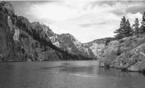
Fig 2.2
The White Cliffs, at which Meriwether Lewis marveled as the expedition passed en route up the Missouri River on May 31, 1805, are now part of the Upper Missouri Wild and Scenic River segment. Photo by Donnie Sexton. Courtesy, Travel Montana.

Highway access to the expedition's route picks up again at Loma, Montana, where U.S. 87 crosses the Marias River near its mouth. Here the two captains made camp on June 2 and paused to consider whether to follow the Marias fork northwest or to continue on the southward-tending fork. For several days small groups carried out a reconnaissance of the two forks of the river. Lewis led one group perhaps sixty miles up the Marias, which flows in from the northwest, while Clark took another group up the southerly fork. The Marias was narrower but seemed to carry a greater volume of water. After weighing the evidence, the two captains determined that the main stem of the Missouri River must be the south fork, although their followers disagreed. Once the decision had been made, the men dug a cache to deposit equipment, supplies, and specimens they would not need for the final dash to the Pacific Coast and also hid one of the pirogues.
As preparations for departure continued at the Marias camp, Meriwether Lewis and four other men set out to look for the Great Falls of the Missouri, which the Hidatsas had told them would require a short
portage to circumvent. Moving upstream above the river bluffs, they could see two massive flat-topped buttes to the west and beyond them the Rocky Mountains and the crest of the Great Divide. On June 13, 1805, Lewis, who was alone while his companions searched for game on the plains south of the river, came upon the Great Falls. This confirmed that he and Clark had taken the right course. What Lewis call a “sublimely grand specticle” was located approximately thirty miles upstream from the future Fort Benton. He described “a sheet of the whitest beaten froth for 200 yards in length and about 80 feet” in height. The outcrop where Lewis stood seemed “to reverberate” as the water pounded against it. As the torrent fell, it swelled “into half formed billows of great hight which rise and again disappear in an instant.” Below the falls Lewis noticed the skeletons and
remains of many buffalo that had fallen into the river while drinking and been precipitated over the cascade. In his description of the lower and largest of the waterfalls, Lewis is the most eloquent in his observations of nature. [IV, 283â285] But there were four more beautiful waterfalls upstream: Crooked Falls, Rainbow Falls (current name), Colter Falls (no longer visible), and Black Eagle Falls, which lies within the present-day city of Great Falls, Montana. [IV, 296n2, 3] Between Rainbow and Black Eagle falls was the eight-foot-high Giant Spring, described by Clark as the “largest fountain or Spring I ever Saw,” boiling up from under the rocks near the edge of the river and emptying into the Missouri. [IV, 307]

Fig 2.3
Big Falls on the Missouri River, twelve miles east of Great Falls, Montana, photographed in 1910, long before it partially disappeared underwater behind a hydroelectric dam. Photo by G. V. Barker. Courtesy, Montana Historical Society Research Center, Helena.
It was necessary to portage around all of the cascades, a task that consumed three weeks and involved building axles and solid
wheels cut from cottonwood trunks on which to pull the dugout canoes. This portage route swung south of the river, passing through Malmstrom Air Force Base and the southwestern edge of Great Falls before returning to the river at the White Bear Islands. These islands, three miles upstream from the mouth of the Sun River (which Lewis and Clark called the Medicine River), provided a base for refitting before the expedition continued southward up the Missouri toward the Three Forks.
At the White Bear Islands, Lewis put together the iron skeleton for a shallow draft boat. The portage, which began on June 22, was often excruciatingly difficult and painful. The men pulling the dugout canoes and their cargo suffered especially from mosquitoes, hailstorms, and the spines of prickly pear cactus that often had to be removed from the soles of their feet at the end of each day. During one cloudburst, Clark, Charbonneau, Sacagawea, and the baby Baptiste almost perished from a flash flood in the ravine where they had sought shelter. Clark described the countryside as having a “romantick appearance [with the] river inclosed between high and Steep hills Cut to pieces by revines but little timber and that Confined to the Rivers & Creek.” There were so few trees that his men had to gather driftwood to light their campfires. Along the river below the red bluffs was a profusion of chokecherries, currants, and gooseberries. [IV, 332] Thousands of bison roamed the area, and the grizzly bears (“white” bears) attracted by the animals' drowned corpses constituted a frequent nuisance, if not a menace, to the men working in the vicinity of the island camp.
Meriwether Lewis's “iron boat” was launched on July 9. However, lacking the proper pitch to caulk the seams, the elk and buffalo hides that covered the frame were unable to keep out water. Without the boat, it was necessary to fashion new dugout canoes from cottonwood trunks before proceeding. Finally, on July 15, the Corps of Discovery resumed its journey to the headwaters of the Missouri River, leaving the open country around the falls and entering a canyon in which the Missouri River cut its way through the western end of the Big Belt Mountains. Today, Interstate 15 follows the canyon as far as Wolf Creek and then parallels the river a few miles to the west. Through the Gates of the Mountains north of Helena, Montana's capital, the main group continued by water under Lewis's guidance. On July 19 Lewis noted that the river was now between 100 and 150 yards wide and deepening, and the current was increasing in velocity. That evening the eight dugouts entered a stretch pressed on both sides by cliffs, which Lewis estimated to be about 1,200 feet high: “[E]very object here,” he wrote, “wears a dark and gloomy aspect. The tow[er]ing and projecting rocks in many places seem ready to tumble on us.” Lewis dubbed the nearly six-mile passage beneath these forbidding cliffs, which today lie between Holter and Hauser dams, the “Gates of the Rocky Mountains.” [IV, 402â403, 405n4]