1493: Uncovering the New World Columbus Created (9 page)
Read 1493: Uncovering the New World Columbus Created Online
Authors: Charles C. Mann
Tags: #Americas (North; Central; South; West Indies), #Expeditions & Discoveries, #United States, #Colonial Period (1600-1775), #History


Jamestown was founded inside the small indigenous empire of Tsenacomoco. Most Tsenacomoco villages were located along the rivers that served as the empire’s highways. Because the water at the river mouths was brackish, the villages were mostly upstream. The English put Jamestown as far upriver as they could—but not far enough to avoid the bad water. Even the groundwater was salty.
Click
here
to view a larger image.
The lack of domestic animals had momentous consequences. In a country without horses, donkeys, and cattle, the only source of transportation and labor was the human body. Compared to England, Tsenacomoco had slower communications (no galloping horses), a dearth of plowed fields (no straining oxen) and pastures (no grazing cattle), and fewer and smaller roads (no carriages to accommodate). Battles were fought without cavalry; winters endured without wool; logs skidded through the forest without oxen. Distances loomed larger when people had to walk from place to place; indeed, in terms of the time required for Powhatan’s orders to reach his minions, Tsenacomoco may have been the size of England itself (it was much less populous, of course).
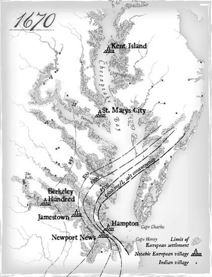
Chesapeake Bay is the remains of a giant meteor crater. The impact shattered rock for miles, letting seawater infiltrate. The U.S. government suggests that salt levels should not exceed 20 milligrams per liter (mg/L); Jamestown water had more than twenty times as much and other settlements had even higher levels.
Click
here
to view a larger image.
Just as most Europeans lived in small farm villages, most of Powhatan’s people—the “Powhatan Indians,” as the newcomers called them—lived in settlements of a few hundred inhabitants surrounded by large tracts of cleared land: fields of maize and former maize fields. The villages clustered along the three rivers—the Rappahannock, York, and James—that served as the empire’s main thoroughfares. Sailing up the James when they arrived, the English saw the banks lined with farms, fields greenly shimmering with newly planted maize, stands of tall trees interspersed among them.
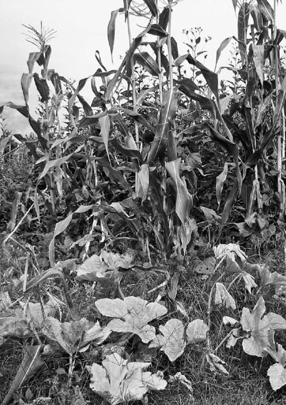
Rather than covering fenced plots with neat rows of wheat, the Powhatan planted many crops at once, as shown in this replica Wendat (Huron) garden in the Crawford Lake Conservation Area in Ontario, Canada. These farms and gardens were so different from anything the English knew that the newcomers often couldn’t recognize native fields as cultivated land. (
Photo credit 2.2
)
Europe, too, had its own prosperous riverside farms. But there the similarities ended. To create a farm plot, Europeans cleared forestland, yanked out the stumps with horses and oxen, and plowed the result, again with horses or oxen, until it was a flat expanse of nearly bare soil. In these stripped areas farmers planted single crops: solid rustling expanses of wheat or barley or rye. Fallow plots were used as pasture. Dotting the open areas were patches of forest, clearly demarcated as such, used for hunting and wood.
Lacking draft animals and metal tools, the Powhatan perforce used different methods and obtained different results. They toppled trees by circling their bases with a ring of fire, then laboriously hacked at the burned zone with stone axes until the trunk collapsed. Brush and slash were put to the torch, leaving a heave of blackened stumps. Around the stumps farmers dug shallow holes with long-handled hoes made from bone or clamshells, dropping in each hole a few kernels of maize and several beans. As the maize grew, the young colonist Henry Spellman observed, “the beans run up thereon”—twining themselves around the growing maize. Below the maize grew squash and gourds, pumpkin and melon, common beans and runner beans, ropy vines asprawl in every direction. Here and there patches of thick-leaved tobacco plants stood. The ensemble of charred stumps, hummocked land, and overlapping crops could stretch for considerable distances: “thirty to forty acres of treeless land per capita,” in one historian’s “conservative” estimate. Smith saw family plots that covered as much as two hundred acres—a third of a square mile.
Except for defensive palisades, Powhatan farmers had no fences around their fields. Why screen off land if no cattle or sheep had to be kept inside? The English, by contrast, regarded well-tended fences as hallmarks of civilization, according to Virginia D. Anderson, a historian at the University of Colorado at Boulder. Fenced fields kept animals in; fenced woodlots kept poachers out. The lack of physical property demarcation signified to the English that Indians didn’t truly occupy the land—it was, so to speak, unimproved. Equally unfamiliar was the Powhatan practice of scattering their farm plots within larger cleared areas. To the Indians, fallow lands were a kind of communal larder, a place for naturally occurring useful plants, including grains (little barley, sumpweed, goosefoot), edible greens (wild lettuce, wild plantains), and medicinals (sassafras, dogbane, smartweed). Because none of these species existed in Europe, the English didn’t know the groundcover was useful. Instead they saw “unused” land, something that bewildered them. How could Indians go to the trouble of clearing the land but then not use it?
Even Tsenacomoco’s streams were different than their English equivalent. English waterways ran swiftly in the spring, scouring away the soil from steep banks, then turned to dribbling trickles in July and August. Beyond the riverbanks the land was drier; one could hike for miles in summer without stepping into mud. Chesapeake Bay was, by contrast, a seemingly endless patchwork of bogs, marshes, grassy ponds, seasonally flooded meadows, and slow-moving streams. It seemed to be wet
everywhere,
no matter what the season. Credit for the watery environment belongs to the American beaver
(Castor canadensis)
, which had no real English equivalent. Weighing as much as sixty pounds, these big rodents live in dome-shaped lodges made by blocking streams with mud, stones, leaves, and cut saplings—as many as twenty dams per mile of stream. The dams smear the water across the landscape, so to speak, transforming a rushing rivulet into a series of broad pools and mucky wetlands linked by shallow, multiply branched channels. Indians regarded this as a fine thing—easier to take a canoe through a set of ponds than a narrow, quick-flowing stream. English accounts, by contrast, are filled with descriptions of colonists unhappily stumbling through the sopped countryside.
2
The freshwater marshes favored the growth of tuckahoe (
Peltandra virginica
, arrow arum), a semi-aquatic plant found in stands throughout the eastern United States and Canada. Tuckahoe has a bulb-like, underground rhizome (enlarged stem area used for storage) that every spring sends out a thin stalk with a long leaf shaped like a child’s sketch of an arrowhead. It was a standing larder for the people of Tsenacomoco, always ready in the springtime if they exhausted the maize from the previous fall. Standing shin deep in the marsh, women mucked about with their bare feet and hands, gradually working loose the roots. The work was unpleasant; when I dug up some tuckahoe one warm spring day in Virginia, I ended up perspiring in the heat even as the cold mud numbed my feet. Tuckahoe root contains calcium oxalate, a potentially fatal poison. To break down the toxin, women sliced the peeled root, baked the slices, then ground them into flour with a mortar and pestle. At home I made tuckahoe flour with an oven and a food processor, then added water and boiled up some porridge. One mouthful was enough to tell me why native people preferred maize.
Surrounding the cleared areas and the fruitful marshes was the wood, splendid with chestnut and elm, but hardly untouched. Like the fields, the forest was shaped by native fire. Every fall Indians burned the underbrush, sending ash billowing into the heavens; when ships approached during fire season, the Dutch merchant David Pieterszoon de Vries observed in 1632, “the land is smelt before it is seen.” From the embers emerged tender new growth, attracting deer, elk, and moose. These were hunted by fire. Men drove the animals into ambushes with flaming torches, herded them toward waiting archers with strategically placed bonfires, encircled them terrified within mile-long walls of flame. Prowling through the woods one evening, John Smith navigated “by the aboundance of fires all over the woods.”
Regular fall burning kept the Maryland forest so open, the Jesuit priest Andrew White wrote in 1634, that “a coach and four horses may travel [through it] without molestation.” The statement is hyperbole, but not entirely false—rather than paving roads, Indians used fire to make what the ecological historian Stephen J. Pyne has called “corridors of travel.” Well-used paths could be six feet wide, hundreds of miles long, and cleared completely of brush and stones. Occasionally one did find unburned patches of land, Virginia colonist William Byrd warned, and these were dangerous. In those places, “the dead Leaves and Trash of many years are heapt up together, which … furnish fewel for a conflagration that carries all before it.” Because Indian burning killed underbrush and saplings, the forest encountered by the early English colonists was a soaring space, hushed as a cathedral, formed by widely spaced walnut and oak six feet in diameter—a beautiful sight, but one just as artificial as the burned-off clearings. “Much as cooking helped rework an intractable environment into food and as the forge refashioned rock into metals,” Pyne explained, native fire “remade the land into usable forms.”
Like the English countryside the colonists left behind them, Chesapeake Bay had been refashioned by its inhabitants into a working landscape. And just as the tidy English checkerboard of fields and woodlots was essential to English culture—indeed, to England’s survival—the jumbled patchwork of ecological zones in coastal Virginia was essential to Powhatan culture and survival. But to the newcomers the Virginia coast was not a humanized place. They saw it as a random snarl of marshes, beaver ponds, unkempt fields, and hostile forest. If the English wanted to live and prosper in this new place in their accustomed manner, they would have to transform the land into something more suitable for themselves.
THE RISK POOL
Most accounts of Jamestown focus on John Smith. No surprise: Smith makes great copy. He was a poor boy who made good with luck, nerve, and self-promotion—in just eighteen years he published no less than
five
autobiographical accounts of his deeds. (To be fair, one was printed without his knowledge.)
The True Travels, Adventures and Observations of Captain John Smith
(1630), his major autobiography, is a wild tale of an orphan who left home at thirteen, fought in the Netherlands, lived in a lean-to teaching himself Machiavelli and Marcus Aurelius, battled “a rabble of Pilgrimes of divers Nations going to Rome” aboard a ship in the Mediterranean (they threw him overboard), and became a pirate in the Adriatic—all in the opening chapter. By chapter 4 (its title: “An Excellent Stratagem by Smith”) he is using torches to send coded messages between mountaintops—a technique from Machiavelli—as he coordinates a battle in what is now Hungary. Later chapters reveal: